• Skip to primary navigation
  • Skip to main content
  • Skip to primary sidebar
  • Skip to footer
Jennifer Marohasy

Jennifer Marohasy

a forum for the discussion of issues concerning the natural environment

  • Home
  • About
  • Publications
  • Speaker
  • Blog
  • Temperatures
  • Coral Reefs
  • Contact
  • Subscribe

Great Barrier Reef

Naming a First Old Porites, Craig

February 5, 2021 By jennifer

Knowing the truth has always been a challenge requiring an amount of discipline. And it is getting that much harder in this age of disinformation. How can we distinguish reality from fantasy, truth from propaganda?

Science used to be so useful for this. But many government-funded reef research programs now amass data to prove a bad impact from global warming, and other things. There is not much hypothesis testing as such – not even about how coral growth rates are affected by increasing sea temperatures.

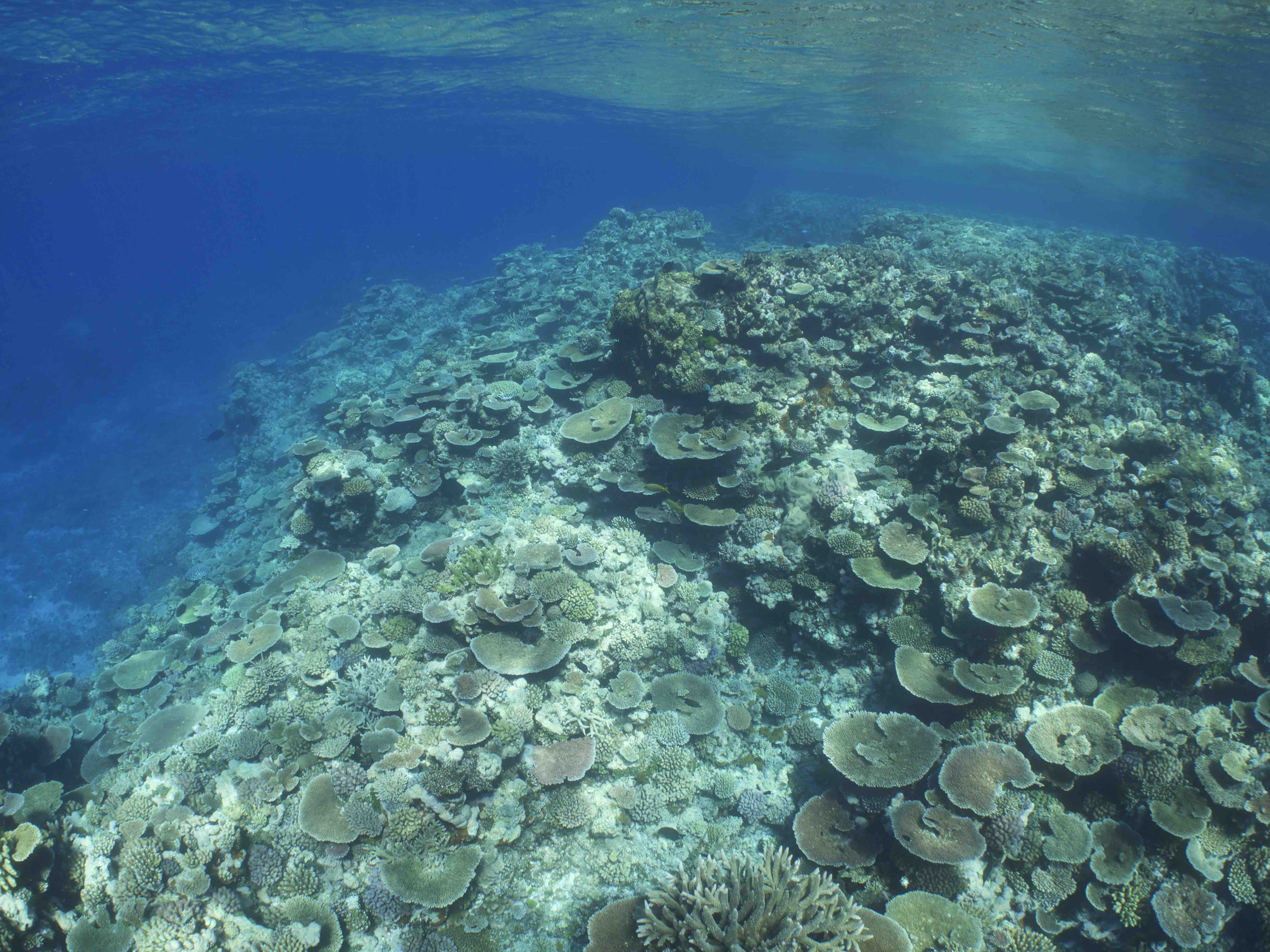
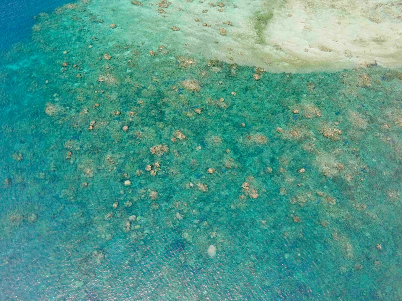
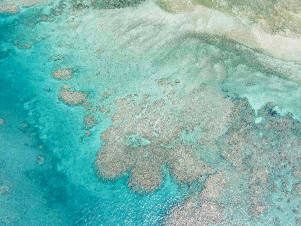
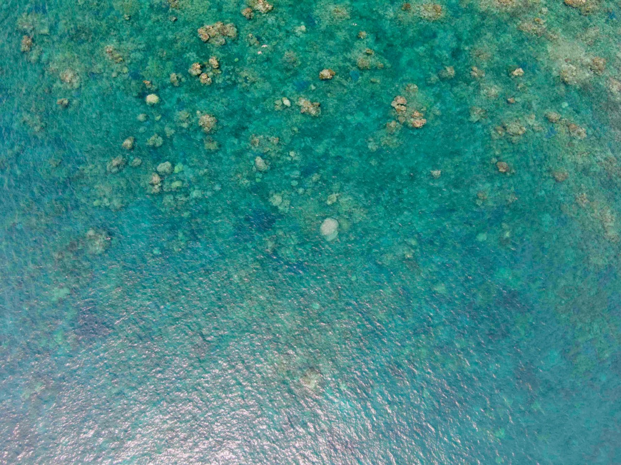
Coral reefs are amongst the most diverse, species-rich and spectacularly beautiful ecosystems on Earth. The largest and best known of these is the Great Barrier Reef and there was once a program of coring, with an annual average growth rate reported for the entire Great Barrier Reef. In the beginning it was hypothesized that as temperatures increased coral growth rates would increase too, which is a good thing – right?

From Chapter 1 of Climate Change: The Facts 2017, the previous book in the series I’m editing.

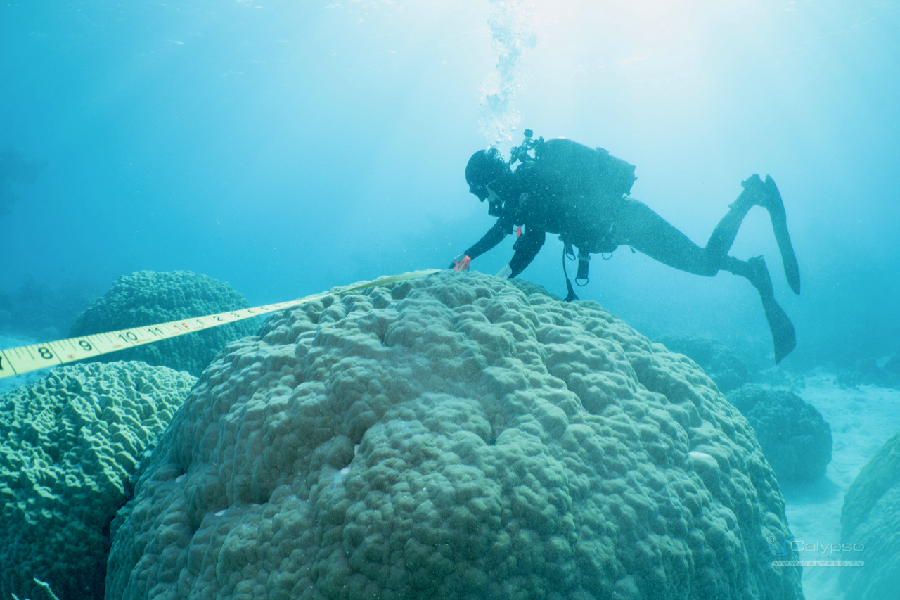
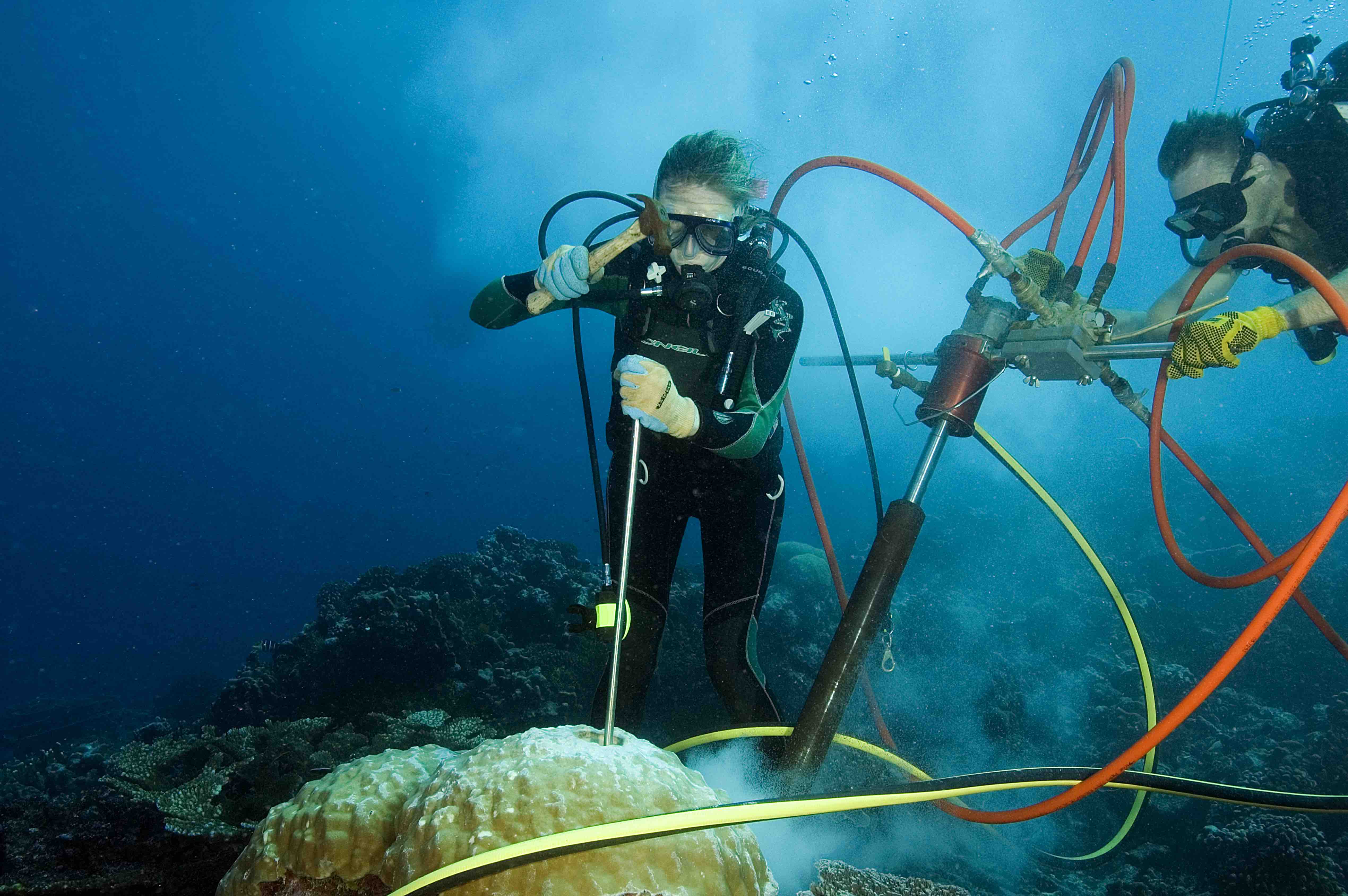
In the beginning the Australian Institute of Marine Sciences (AIMS) sampled the really old large Porites. These are the bolder corals with distinct annual bands – variations in the density and length of these annual bands are an indication of changing growth rates.

Then, after 1990, they started mixing up the young (less than 15 years old) with the old (more than 100 years old) samples, which generated some confusing results. A study published in Marine Geology (volume 346) that used only data from the large old corals showed an increase in calcification rates (coral growth rates) over the last 100 years, rather than a sudden drop off after 1990.

Then AIMS just stopped coring the really old Porites and stopped calculating an annual average growth rate. It is now 16 years since AIMS published an average coral growth rate for the Great Barrier Reef. This makes it that much harder to know if the Great Barrier Reef really is dying – or if this is just scare mongering to generate research funding.

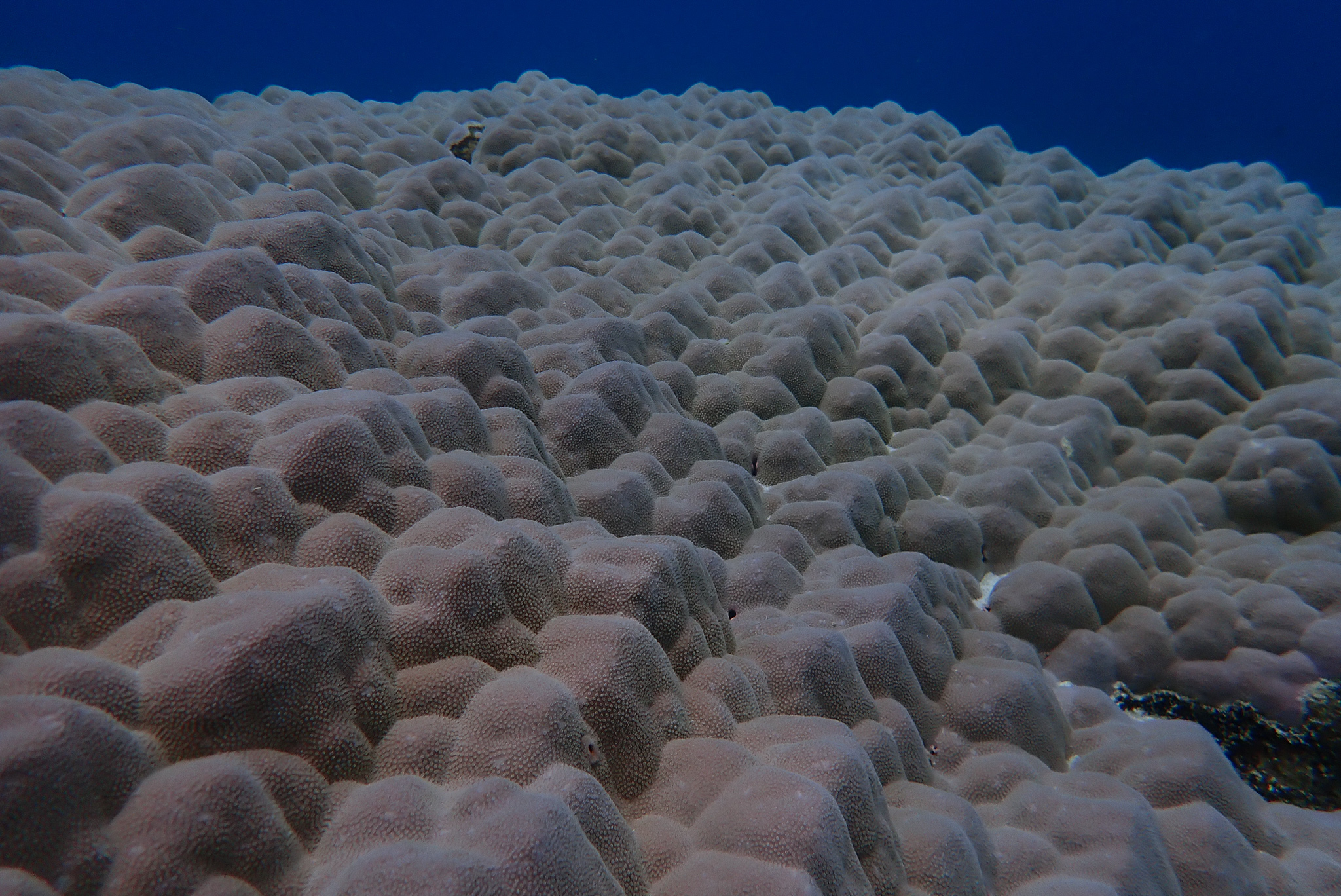
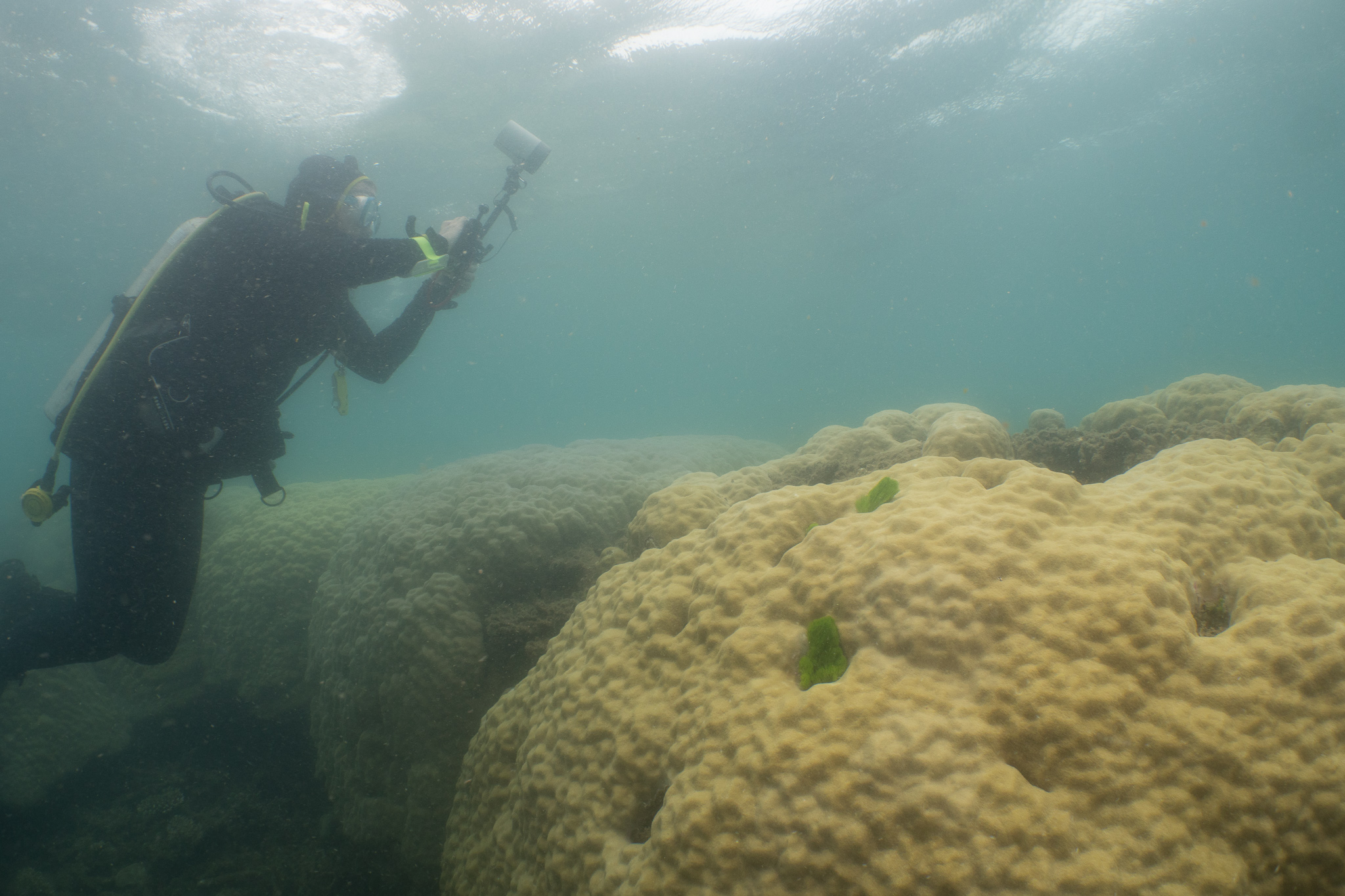
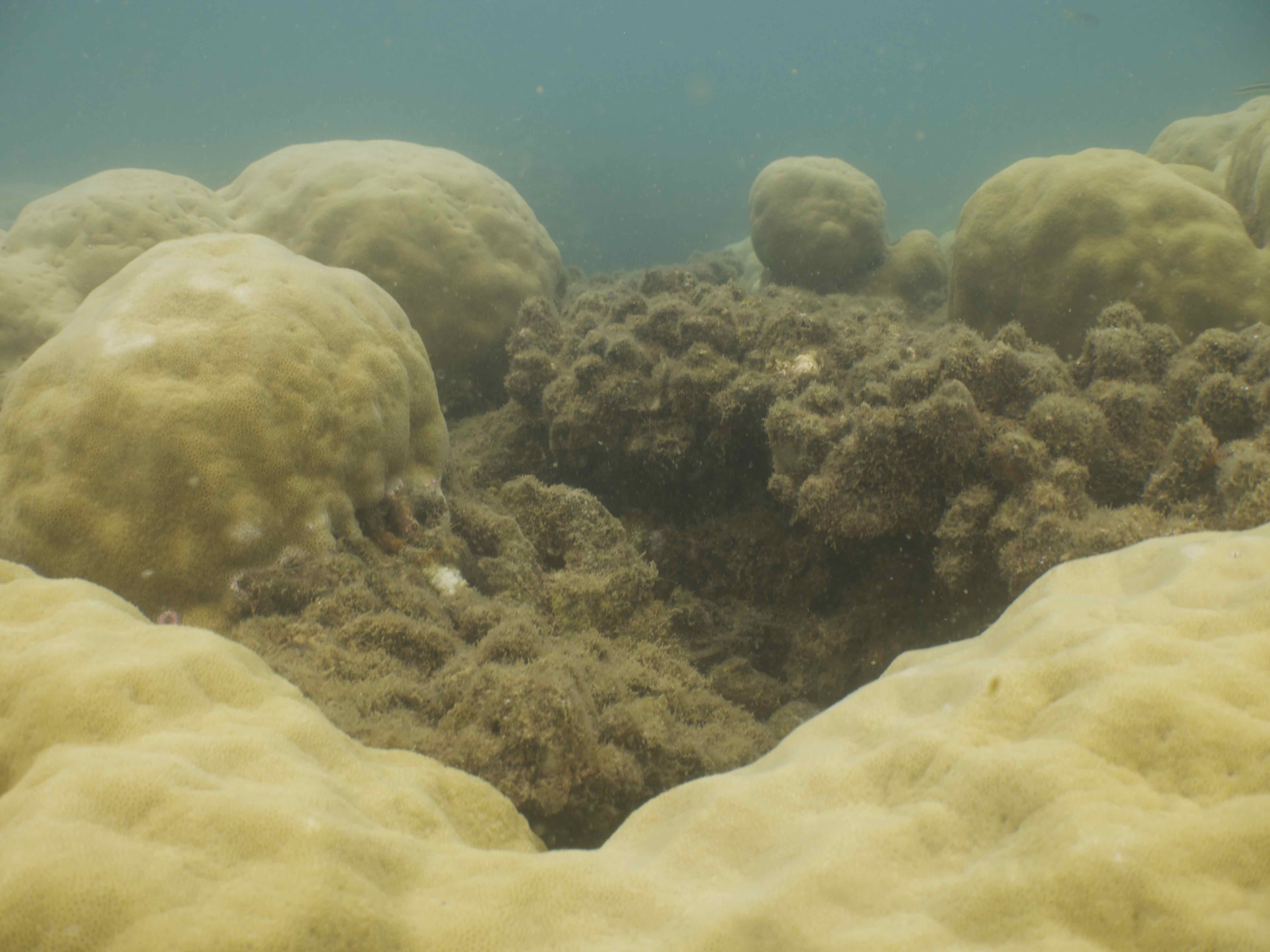
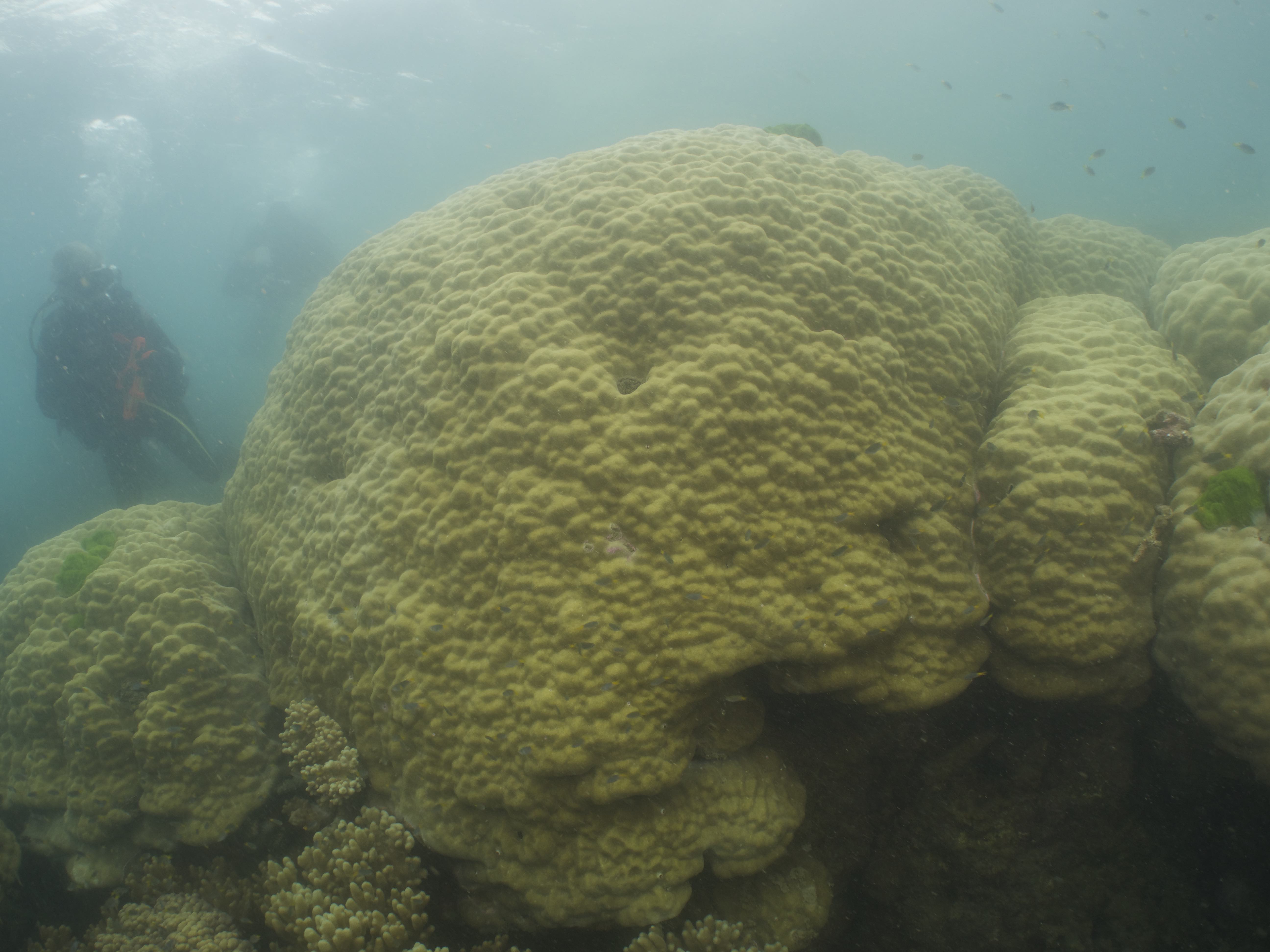
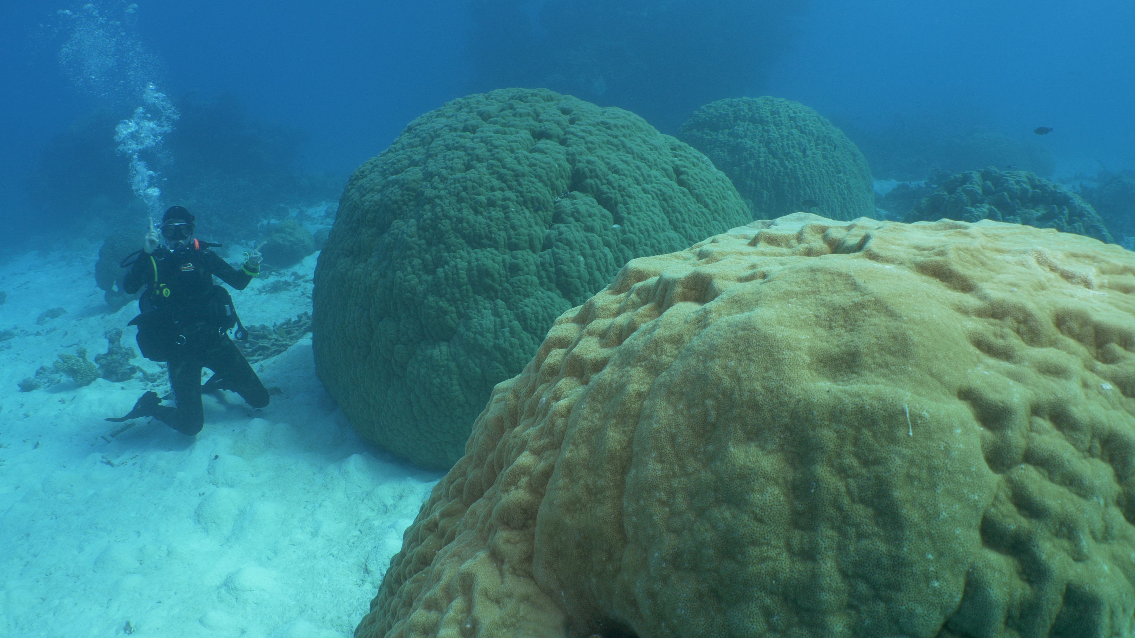
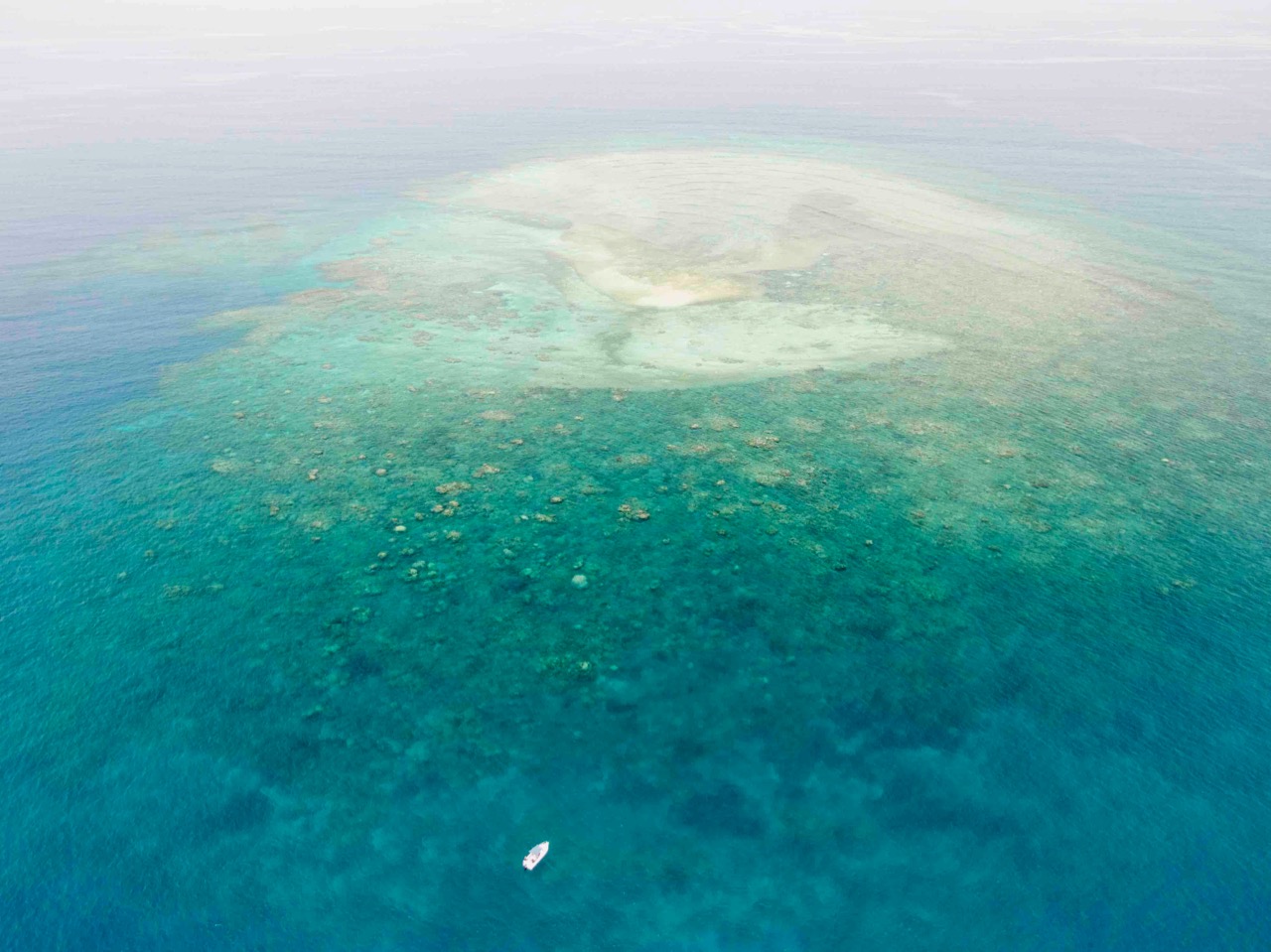
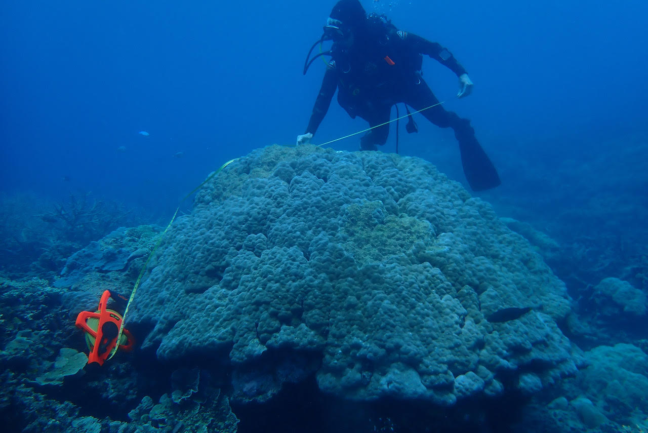
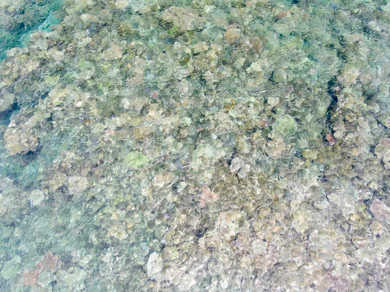
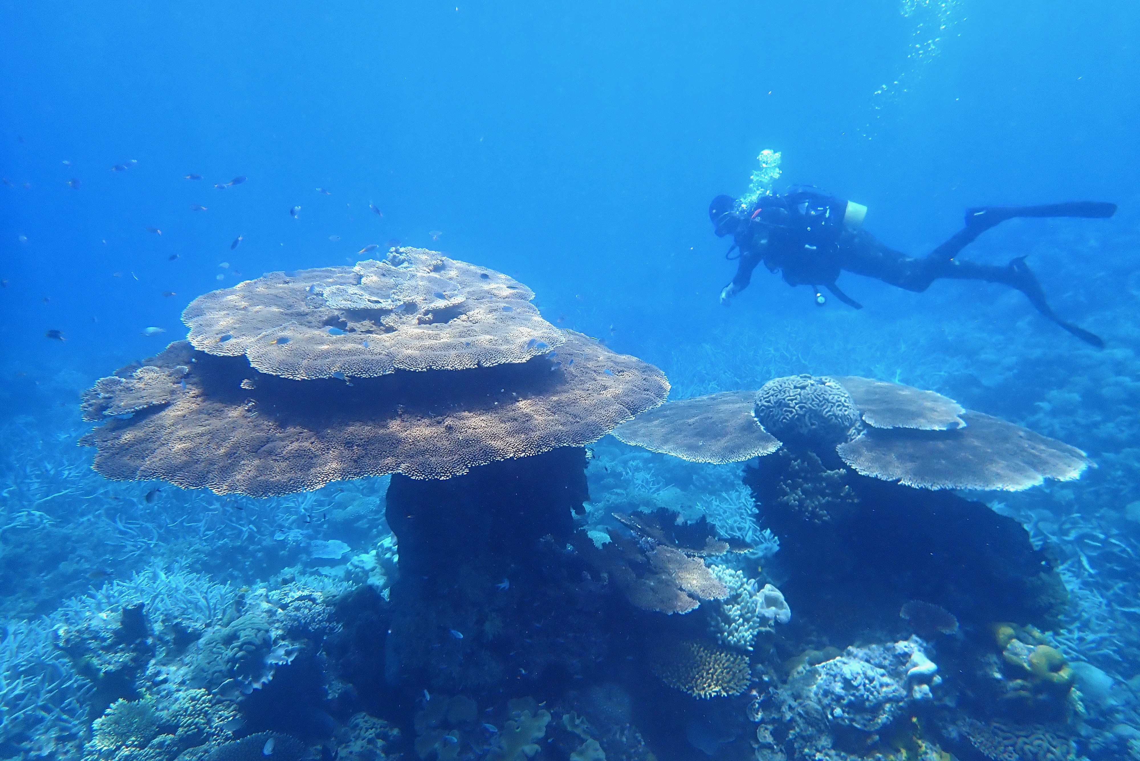
I think we should start an inventory of the oldest and largest Porites, to acknowledge and celebrate them. The largest massive bolder coral that I have measured so far is from Pixie Reef, just to the north east of Cairns.

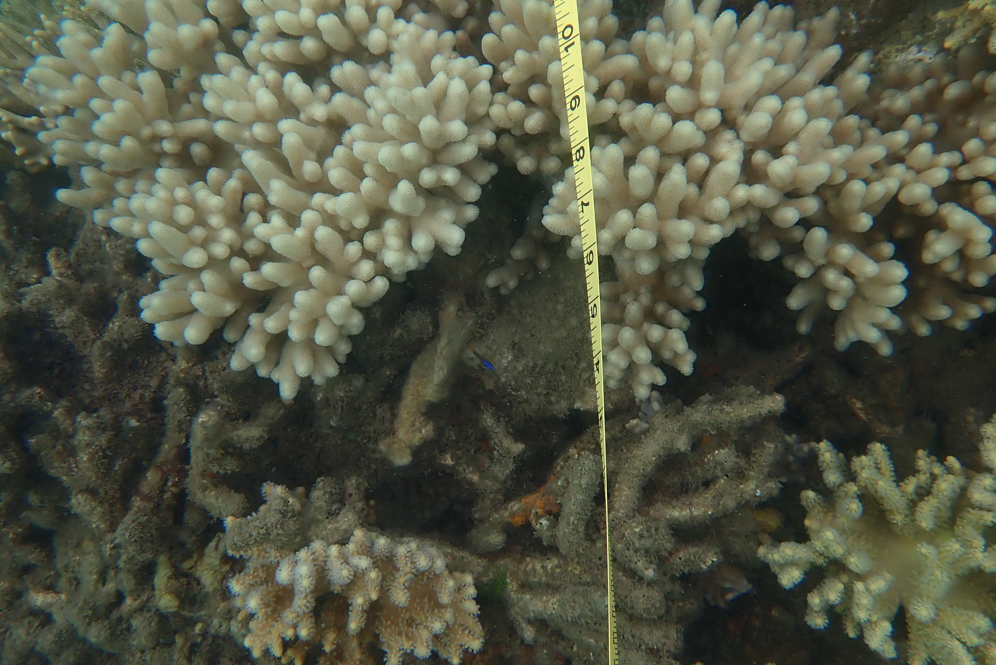
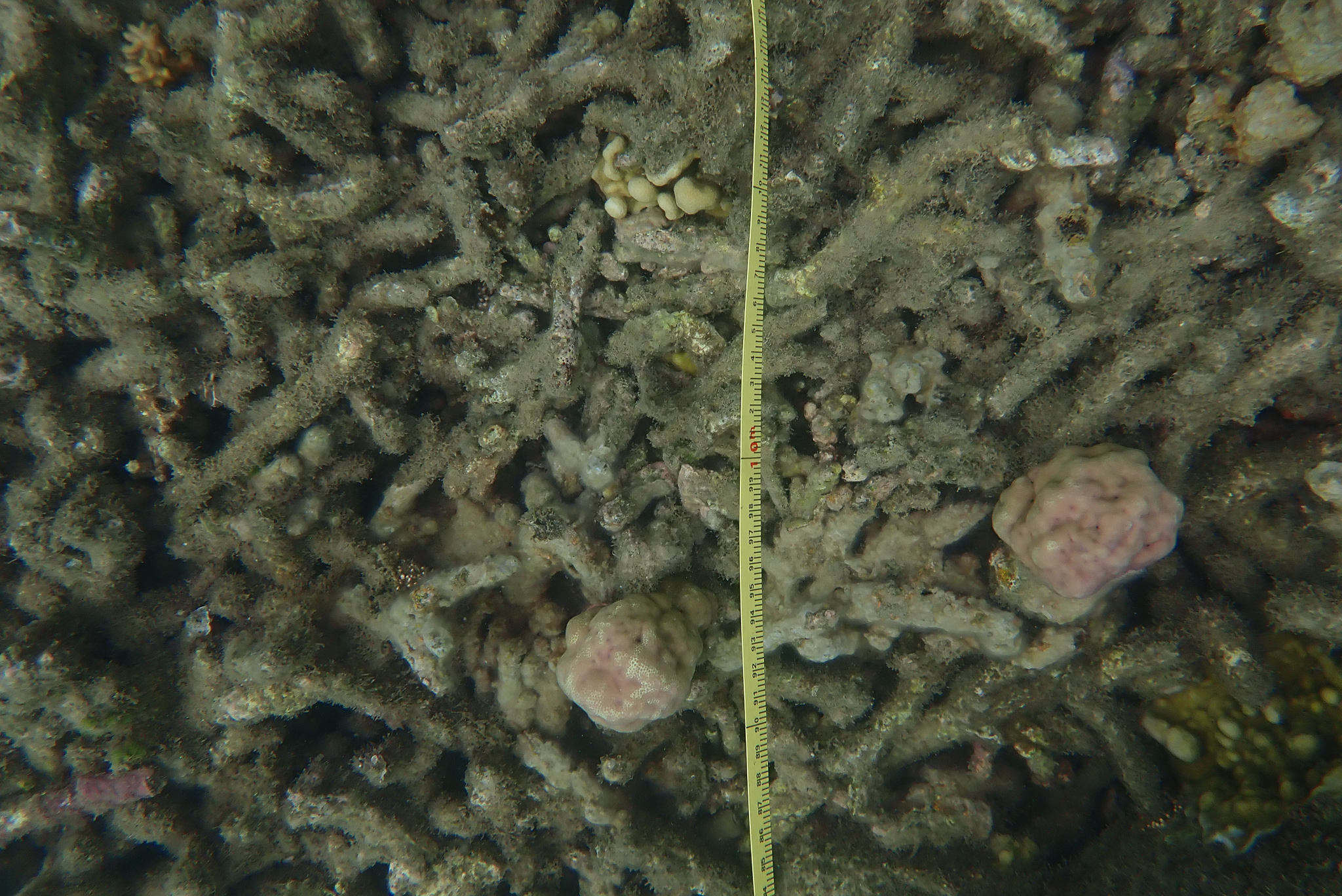
Does anyone want to guess how high and wide this very large old Porites coral colony is? These photographs were taken on 25th November 2020.

I was wondering how we might distinguish the individual coral colonies: what we might call it? Then I remembered how it all began with naming cyclones:

It started in 1887 when Queensland’s chief weather man Clement Wragge began naming tropical cyclones after the Greek alphabet, fabulous beasts, and politicians who annoyed him.

After Wragge retired in 1908, the naming of cyclones and storms occurred much less frequently, with only a handful of countries informally naming cyclones. It was almost 60 years later that the Bureau formalised the practice, with Western Australia’s Tropical Cyclone Bessie being the first Australian cyclone to be officially named on January 6, 1964.

Other countries quickly began using female names to identify the storms and cyclones that affected them.”

I was wondering what we might call this massive Porites amongst the Pixies, and then I received a phone call from my dear friend Craig Kelly MP.

Following in the early tradition of Clement Wragge for cyclones, I though we might name this Porites after Craig – a truth seeker and for many an annoying politician.

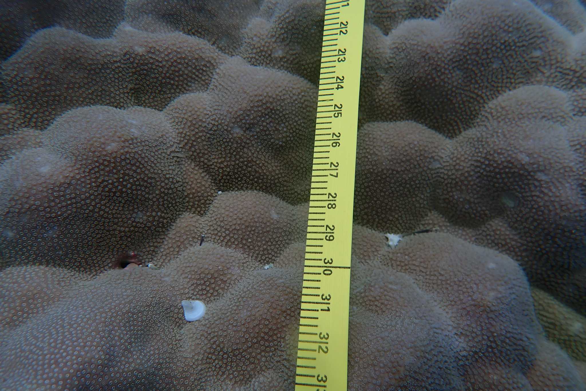
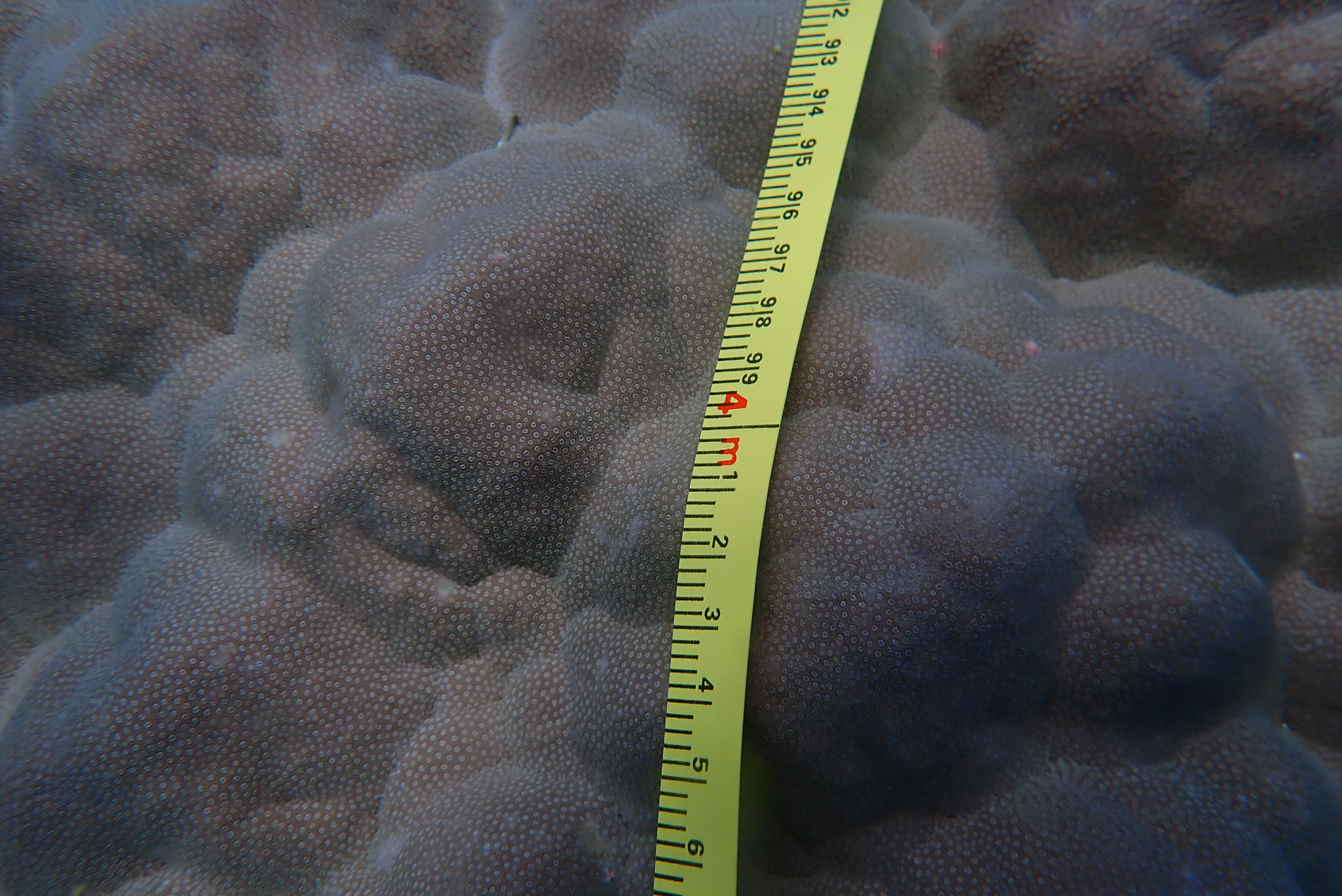
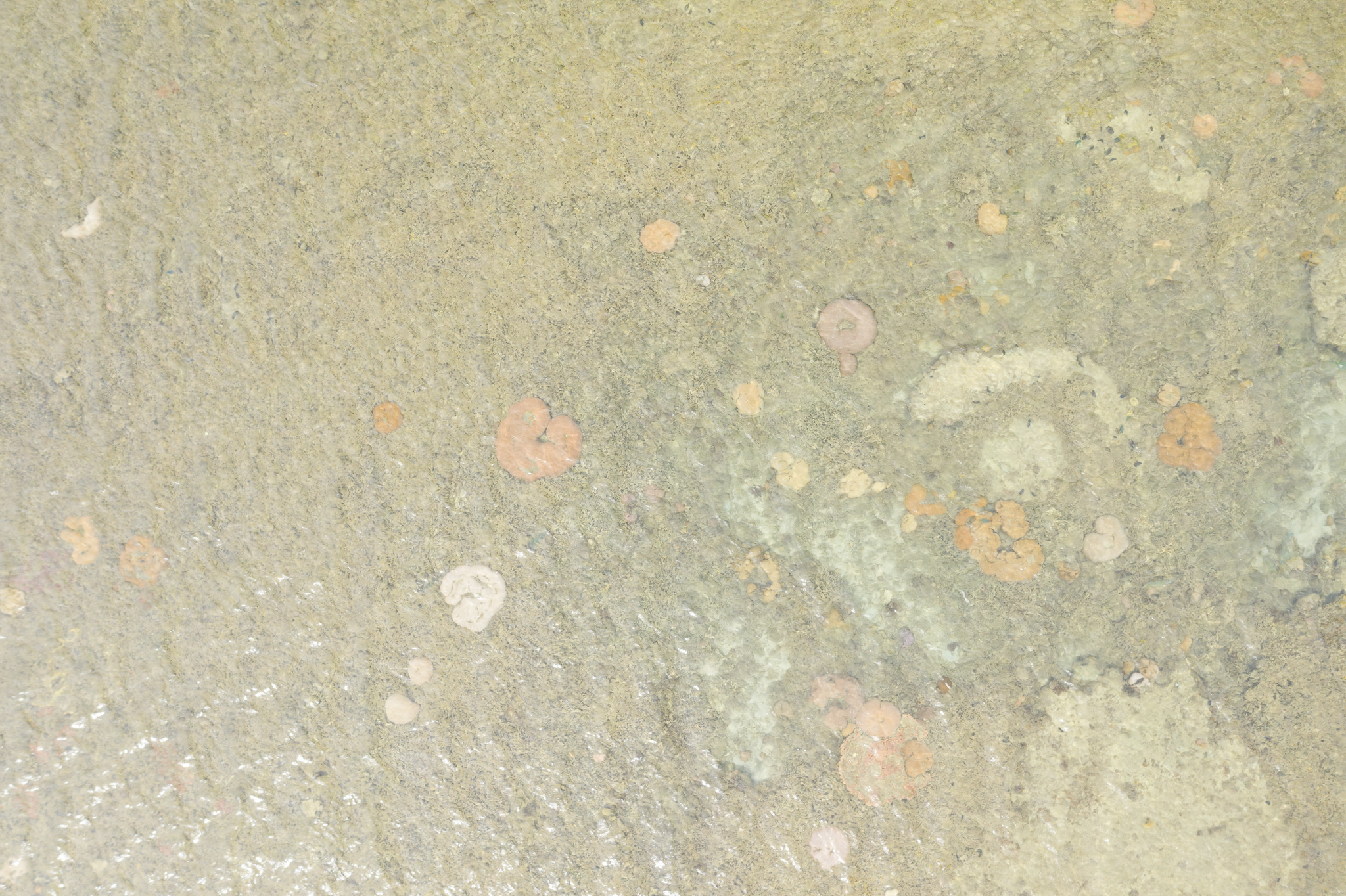
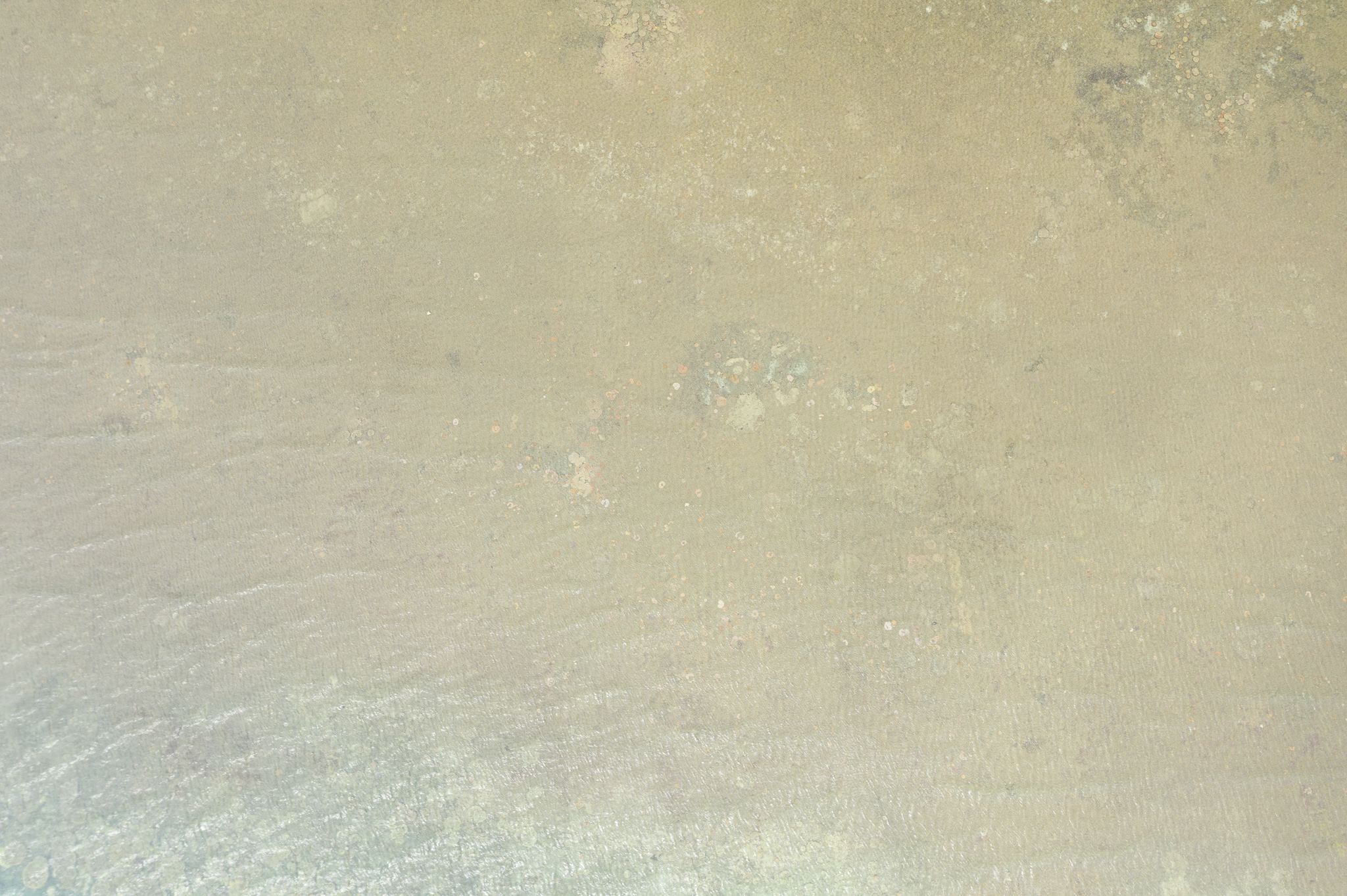
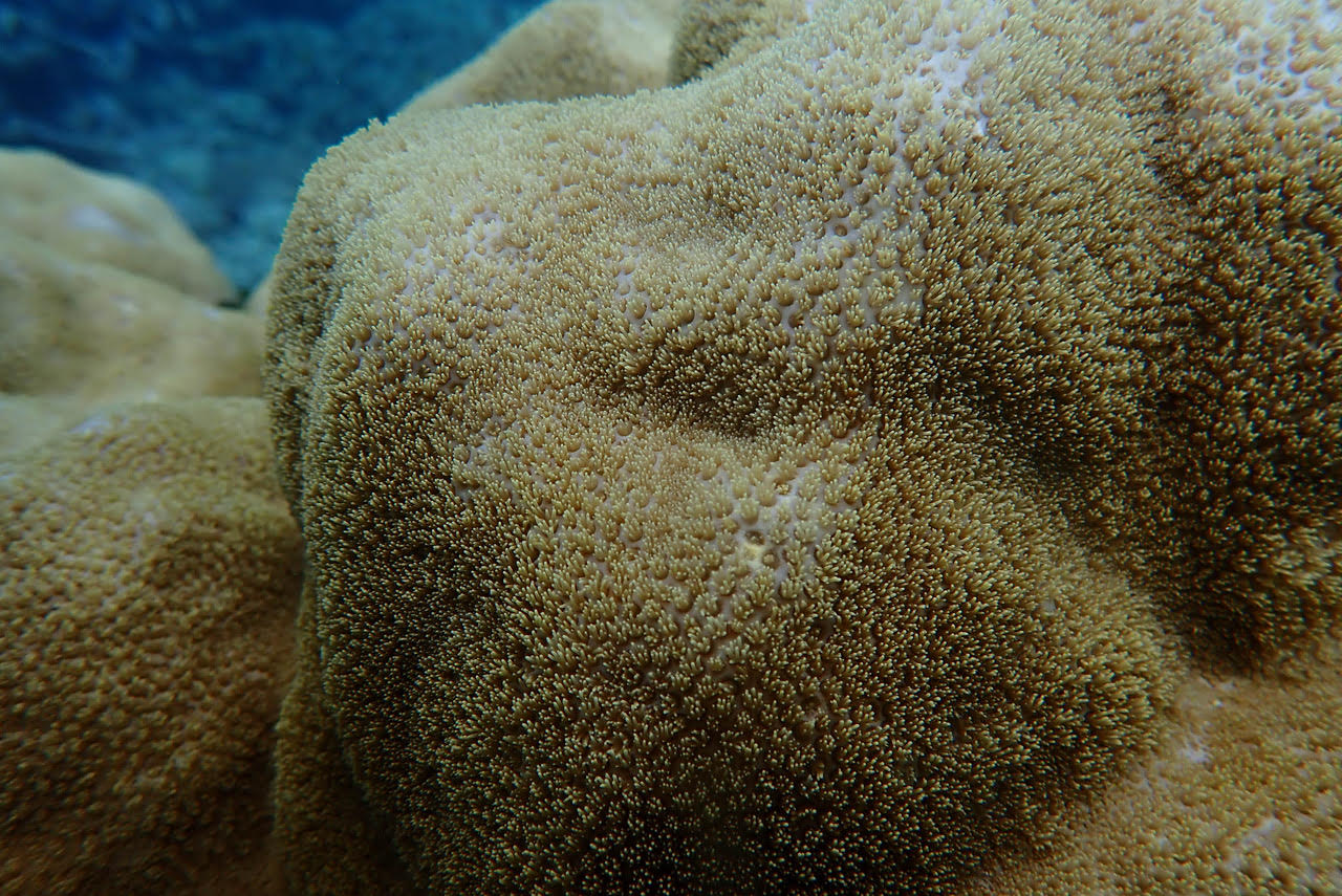
These close-up photographs of Porites Craig taken at the same time as the wide-angle images, show that the corallite wall is still intact and some have their tentacles extended. So, we can conclude Porites Craig was quite healthy on 25th November 2020. If AIMS cored this coral we could know the true climate history of this place back perhaps 500 years.

Ends.

Filed Under: Information Tagged With: Great Barrier Reef, Porites

Measuring Old Corals & Coral Reefs (Part 2)

January 20, 2021 By jennifer

Late last year, I went on an expedition in search of a type of very old coral known as massive Porites. Stuart, Shaun and I dived five very different coral reefs between Cairns and Townsville.

The first was an inshore fringing coral reef to the leeward side of High Island. High Island is close to the Australian mainland, and not far from the Russell and Mulgrave rivers that drain a catchment with sugarcane farms. More than almost any other coral reef along the Queensland coast, this inshore reef would likely show impacts from agriculture – if there are any.

High Island with its fringing coral reef.

This coral reef has a very broad and long reef crest. On the afternoon of 28th September, when we visited, this habitat was covered in perhaps one metre of water. Along the seaward edge of this fringing coral reef, the crest gives way to the reef slope where we found so many massive Porites – so many of the old corals that we were searching for.

The water was quite turbid, which is common at these inshore reefs depending on the prevailing wind.

On the reef slope, many of the Porites (these massive bolder corals), were more than 2 metres in height and width, and a golden colour. There were lots of little fish. I found a peg that perhaps marked a Porites that been cored more than 17 years ago. The Australian Institute of Marine Sciences (AIMS) once cored corals at this reef.

Once upon a time, the scientists drilled into the corals and extracted a core from which they created a slither. Then, under x-ray, they counted the annual bands with the varying lengths and thicknesses of each band being a measure of annual growth rates. Yes, these massive bolder corals have annual growth rings – like tree rings.

Then we found another peg, perhaps marking another of the corals that used to be cored. But our job was not to count the pegs, rather to measure the height and width of the Porites – of the old corals.

The massive Porites at the beginning of the reef slope were of a uniform height. This is because their vertical growth is constrained by sea level. The growth rates of coral colonies slows as they come within 2- 3 metres of the surface. So, the annual growth bands of these Porites, at this reef, may not be a good indicator of climate change, because they are so constrained by sea level.

Our expedition was in searching for Porites, but not any Porites: Porites suitable for coring to determine the effect of climate change on coral growth rates.

The Porites are growing to a uniform height, just below the sea level.

At any given location, the sea level changes with the tides. Sea level, the tides, can vary by 3 metres in one day at this reef. And the very lowest tide in the 18.6-year lunar (moon) declination cycle may cause a tide that is a foot (30cm) lower than the lowest tide in an average year. (There is more about this in our new book ‘Climate Change: The Facts 2020’, see page 267, and there is also a Factsheet about tides falling on corresponding El Nino events at the book’s dedicated webpage, see figure 4 at the second link.)

The tides, and so much else that happens at coral reefs, has a lunar/moon influence – both the good and the bad. Coral spawning happens exactly 5 days after a full moon, and the worst coral bleaching events, which were in 1998 and then again in 2016, correspond exactly with the lunar (moon) declination cycle of 18.6 years. If the massive Porites at the coral reef fringing High Island were not constrained by sea level, they would be more dome shaped. But as they grow closer to the surface, their tops are bleached on the lowest tides and then die, so they become flat topped.

The decayed top of a massive Porites growing on the slope at this fringing coral reef.

As the reef crest grows seaward and the coral colonies now growing on the slopes are incorporated into it, these massive Porites may eventually grow into a donut-like form referred to as a microatolls. A microatoll has dead coral in the centre and is surrounded by a ring of live coral.

There are so many ‘donuts’ – Porites microatolls with diameters of perhaps two metres – in the aerial photographs from above the reef crest at High Island. These corals may have become incorporated into the reef crest as the coral reef prograded seaward and so may also be two metres in depth, or the coral colonies/the Porites microatolls may be quite flat bottomed, having started life on-top of the existing reef platform and only ever had the opportunity to grow laterally because they have always been constrained by sea-level.

The High Island reef crest from 10 metres altitude.
The High Island reef crest from 120 metres altitude.

From 120 altitude above the reef crest at High Island, and indeed above most reef crests, it mostly all looks rather drab and desolate – except for the donuts. It is from about this altitude that the chief scientist at the ARC Centre for Coral Reef Studies at James Cook University has decided that more than 50% of the Great Barrier Reef is bleached. His reports make newspaper headlands around the world, and so most people now believe that the Great Barrier Reef is half dead.

To be clear, Professor Terry Hughes flies over hundreds of reef crests, looks out the plane window, and scores them. If more than 60% of the corals looks dead to him the reef is given a score of 4. (This method, and the technical paper, are referenced at the end of this article.)

Except that at this altitude, at which the plane flies, it is actually impossible to see any individual corals – beyond the large donuts, which are Porites microatolls.

While it is impossible to see the littler corals and the colourful fish at this high altitude – from such a distance – there were so many delicate and pretty corals on this reef crest, and even pretty blue fish as you can see in the transect photographs. (There is a new webpage with the photographic transects and a bit more. It will become the data page for High Island reef eventually, hopefully, incorporating species lists and analysis of coral cover and coral health.)

The chief scientist claims to ground-truthed his scores from the aerial flyovers by laying belt transect that are ten metres in length over some of the reef crest. We laid such transects at the High Island reef crest on 28th November 2020. We also laid transects at 5 metres depth. We are planning to go back and lay transects at 10 metres depth.

Photograph of the first transect at 2 metres from the reef crest at High Island.

Just considering the first 10 metre transect from the reef crest at High Island: at 2 metres along, I can see such a pretty beige Lobophytum pauciforum coral. The tentacles are extended along several of the branches. So, I can conclude this is a healthy coral.

Photograph from the transect at 5 metres, at the High Island reef crest on 28th November 2020.

But what about the coral at 5 metres along this photographic transect? It looks bleached! But perhaps this is actually a soft coral, perhaps Sinularia polydactyla which is a type of coral that never has any zooxanthellae, so it can’t bleach.

Photograph from the transect at 10 metres, taken at the reef crest at High Island on 28th November 2020.

But the last photograph in this transect, at 10 metres: the corals are almost all dead and covered in algae. There are, though, two young nobbly Porites emerging from the destruction that could become microatolls eventually. After a hundred years these two pink nobbly things could grow to a metre in diameter and be donut shaped.

While taking the transect photographs at this reef crest Shaun found and also photographed a blue lionfish, Pterois sp..

A lionfish at the High Island reef crest.

While Shaun took the photographs, Stuart took video of the corals along the tape measure, along the transects. This video transect gives a more continuous and a wider-angle view of the corals along each of the ten metres sections of reef. Considering just the last three of the ten-metre sections of video transect which are from the reef crest, how would you score this reef crest?

Given the great variability in coral cover, and coral health, and the diversity of coral species and just along 10 metres of transect, I find it quite difficult to make such a judgement.

Science is not a truth. It is a way of getting to the truth.

If we use the method applied by the chief scientist then we have to choose from just one of five categories for this reef. According to his method, the result of which are regularly reported across the world, you need to choose one of the following categories:
<1% dead, 1-10% dead, 10-30% dead, 30-60% dead, >60%.

So, what is your decision! Is this reef crest 10-30% dead?

Perhaps it would be easier if you just looked at the reef crest from 120 metres altitude and made a decision based on your impression of the corals from this altitude, as the chief scientist does.

The High Island reef crest from 120 metres altitude.

So, what is your decision? From this altitude could it be concluded that this reef crest is more than >60% dead? Would this be a fair assessment, and would it then be fair to conclude that the entire ecosystem at this fringing coral reef is more than 60% dead?

I actually think that there are major problems with the methodology used by Professor Hughes to decide on the state of our coral reefs. I think it inappropriate to attempt to categorise the state of corals from such a high altitude, from more than 100 metres away. I think that the professor should be getting in, and under, the water.

If there is anything that a high altitude aerial photograph is useful for, beyond finding Porites microattols at reef crests, it is perhaps distinguishing the different habitat types at coral reefs. From high up in the air above High Island it is easy enough to see that the reef crest is quite different from the reef slope.

The reef crest ends at the reef slope which is along the seaward side of the High Island coral reef. This aerial was taken on 28th November, 2020. Our 40 foot boat provides some scale, you can see about half of it in this aerial.

The reef slope is the section that falls alway to the sea floor. The most prolific growth and highest biodiversity at a fringing coral reef is typically down the reef slope. I wonder how far down the Porites and other corals grow at this reef? I wonder how far from the reef crest, down the reef slope before the sea floor?

Massive Porites towards the top of the reef slope at High Island, photographed on 28th November 2020.

Acknowledgements

Stuart Ireland took all the aerial photographs, and filmed the transect video. Shaun Frichette took all the transect photographs. These provide some record of the health of this coral reef fringing High Island for that moment in time, for Saturday 28th November 2020.

Reference
T. P. Hughes, J. T. Kerry, and T. Simpson. Ecology 99(2), 2018.

Data set identification code:
Coral bleaching scores of 931 reefs on the Great Barrier Reef (range: 142oE to 152oE, 9oS to 23oS). Bleaching scores are recorded in a .csv attribute table. The attribute table identifies each reef by a unique reef code (following Great Barrier Reef Marine Park nomenclature), reef name (where available), reef centroid (as longitude and latitude), coral bleaching score as a categorical variable: (0) less than 1% of corals bleached, (1) 1-10%, (2) 10-30%, (3) 30-60%, and (4) more than 60% of corals bleached, and date of aerial surveillance.

Methods: We compiled an attribute table of coral bleaching scores for 1156 whole reefs on the Great Barrier in 2016. The attribute table identifies each reef by a unique identifier number and (where available) reef name, the longitude and latitude of the centroid of each reef, a categorical bleaching score of the bleaching status of each reef, and the date the reef was surveyed from the air.
These data were generated from comprehensive aerial surveys of the Great Barrier Reef Marine Park and Torres Strait (Fig. 1) conducted on ten days between 22nd March 2016 and 17th April 2016 when bleaching was at its zenith, but before significant mortality had set in (confirmed by extensive underwater surveys at 260 sites (104 reefs).

The aerial surveys utilised light aircraft and helicopters, flying at an elevation of approximately 150 m (500 ft). We assessed 1156 individual reefs from the coast to the edge of the continental shelf along 14o of latitude. Using the same protocols as earlier aerial surveys conducted in 1998 and 2002 (Berkelmans et al. 2004), each reef was assigned by visual assessment to one of five categories of bleaching severity: (0) less than 1% of corals bleached, (1) 1-10%, (2) 10-30%, (3) 30-60%, and (4) more than 60% of corals bleached.

Underwater surveys of the coral bleaching were conducted at the same time on 104 reefs, to assess the accuracy of aerial surveys, using five 10 x 1 m belt transects placed on the reef crest at a depth of 2m at each site. Observers identified and counted each coral colonies and recorded a 6-scale categorical bleaching score for each one: (1) no bleaching, (2) pale, (3) 1-50% bleached, (4) 51- 99% bleached, (5) 100% bleached, (6) bleached and recently dead. The amount of bleaching for each location is the sum of categories 2-6, i.e. excluding unbleached colonies.

Other Information

There is a High Island data page, with the transect photographs and I’m hoping to add species lists and more to this page: https://jennifermarohasy.com.dev.internet-thinking.com.au/coralreefs/high-island/

Part 1 of this series concerns Pixie Reef, just to the north of Cairns, and can be found here: https://jennifermarohasy.com.dev.internet-thinking.com.au/2020/11/measuring-old-corals-coral-reefs-part-1/ . Like High Island, Pixie is so close to Cairns but such a different reef perhaps in part because it is not fringing a continental island.

This website is archived each year by the Australian National Library:
https://webarchive.nla.gov.au/tep/66941

Filed Under: Information Tagged With: Great Barrier Reef

Reef Heresy? And the Importance of Asking Questions

December 20, 2020 By jennifer

I am so privileged to have written the introduction to Peter Ridd’s new book, ‘Reef Heresy?’. In it I explain that it is of great concern to both Peter, and myself, that those who claim the Great Barrier Reef to be in terminal decline are so unwilling to engage in any form of debate.

Sometimes the quickest way to the truth is through argument, by which I mean disagreement between two or more people with each side given opportunity to present their case and their perspective.

The word ‘heresy’, which is the title of Peter’s book, means ‘opinion profoundly at odds with what is generally accepted’. The heresy is that Peter is not committed to the right political dogma. It is not that he is wrong.

It is interesting that the ‘other side’ won’t debate. They would prefer everyone just believed that the reef is in terminal decline, and that we have catastrophic global warming. And how profoundly sad would that be, if it were true!

The establishment, by which I mean the science managers at James Cook University and the Australian Institute of Marine Science (AIMS), know that it might not be quite so straightforward, and that there could be some issues with some of the science. But, in general, they are convinced that they are right – or at least on the side of right, even if that means being ‘left’. (Ha ha.) They certainly don’t want to have to get into the detail – or have to keep coring the massive old Porites corals from which an overall coral growth rate for the Great Barrier Reef used to be calculated.

Some of this is explained in a discussion I had with Peter when we were last together in Townsville – a discussion hosted by John Roskam and that included some 400 members of the Institute of Public Affairs (IPA) via Zoom.

In this discussion, and more generally, I suggest we should all (both sides) be less quick to lecture and more interested in asking questions.

Peter Ridd suggests towards the end of his book (page 184) that asking questions in science could be made more legitimate through the establishment of explicit ‘Red Teams’ at organisations like AIMS. Yale University professor, Irving Janis, was detailing the inherent problems with working towards a consensus – and labelled this Group Think – back in the 1950s. Professor Janis explained in his important book by the same name, how this will inevitably generate systematic errors. The conclusion of that long book is that it is critical groups encourage scepticism in order to find the possible errors in their favourite theory or plan. I would have thought this to be a no-brainer in a civilization as sophisticated as our own, and one in which being able to forecast the weather day-to-day, month-to-month, and year-to-year is so important especially for the proper management of water infrastructure and water allocations for hydro-electricity as well as growing food crops.

Despite a plethora of history and data suggesting that ideas should always be tested, we live during a time when it is so unfashionable to ask the hard questions. John Roskam ends the YouTube discussion quoting from my new book ‘Climate Change: The Facts 2020’: It is so much better to have questions that cannot be answered, than to live and do science according to answers that cannot be questioned.

Here are a few questions I have, from flipping through the page of Peter’s new book:

1. When was the last major event that caused catastrophic global climate disruption? (see page 200 of ‘Reef Heresy?’)

2. What does Peter think is the second most important environmental issue in Australia? (see page 201 of ‘Reef Heresy?’)

3. Which are the two sources of ‘new nitrogen’ into the Great Barrier Reef? (see page 84 of ‘Reef Heresy?’)

4. When have major outbreaks of Crown-of-Thorn starfish (COTS) occurred on the Great Barrier Reef? (see page 35 of ‘Reef Heresy?’)

5. When did AIMS last publish a Great Barrier Reef average coral growth rate? (see page 7 of ‘Reef Heresy?’)

Jen kneeling beside a massive Porites at Myrmidon Reef on 1st December 2020. These are the corals that AIMS used to core to calculate an average growth rate for Great Barrier Reef corals.

****
The feature image at the very top of this blog post is of Cheryl Ridd, Bill Lindquist, Anne Carter, me and Peter (left to right) on the back verandah in Townsville, one Sunday, just a couple of weeks ago.

Filed Under: Information Tagged With: Great Barrier Reef

Gardens of Old Porites, Without Sharks

December 9, 2020 By jennifer

It is often reported that the Great Barrier Reef is half dead, specifically that the corals are bleached, and the water quality is degraded with pesticides and plastics. If I didn’t know better, I might never want to visit a coral reef, lest I be forced to confront this reality – apparently all our fault. Except the coral reefs that I dived last week each made me feel so alive, and in awe of their extraordinary beauty – especially Myrmidon reef which is an ancient and detached coral reef that juts out into the Pacific Ocean on the eastern edge of the Great Barrier Reef. But we didn’t see many sharks.

The sparse reef crest at Myrmidon with Stuart measuring out 10 metres for the first transect, while also holding his camera.

The coral reef called Myrmidon is perhaps as old as the city of Troy. In mythology, that city existed about 5,000 years ago and it was attacked by Achilles and 50 ships each carrying 50 Myrmidons. Paleo-climatologists will argue that that geological period, known as the middle Holocene (7,000 to 4,500 years ago), was much warmer than the present with sea levels at least 1.5 metres higher than they are today along the east coast of Australia including at the Great Barrier Reef.

Perhaps everything seemed unusually magical last Wednesday at Myrmidon because I dived into such crystal-clear water, and it was so sunny. Looking back over the video footage, Myrmidon reef did not have particularly luxurious corals, but there was an iridescence and a beauty that I’ve not seen before. It was so evident that the live corals were growing on-top of dead corals, not one or two generations dead, but representing thousands of years of growth and destruction from cyclones and bleaching events. The reef was unashamedly beautiful yet with so much exposed that represented layers and layers of dead coral. The regrowth was so clearly on eroded antecedent surfaces.

Where we first jumped in at Myrmidon, the coral was sparse and stunted and there were piles of coral rubble some newly dead and covered in green algae. My dive-buddy Shaun, and underwater videographer Stuart, swam with me around a ledge that led us down into an underwater canyon. Green parrot fish swam metres above a giant clam with an ink black body speckled with florescent blue zooxanthellae. I knelt beside it, I was 17 metres under-the-water and feeling part of another world. Stuart was not too far away, deciding which of the massive Porites along the walls of the canyon we would measure, and Shaun would photograph – then we ran the photographic transect.

Porites are the old boulder corals, which like the oldest trees in temperate forests, can be cored to reveal a climate history. I was not at Myrmidon to core the Porites, but just to find out if any still existed and to measure and photograph them – as well as running the photographic transects. But really, I just wanted to sit next to the black clam speckled blue, which had thick olive-green shiny lips and watch it breathe and feed through its two siphons.

We cruised a total of 263 nautical miles (nearly 500 kilometres) last week in search of the old corals, the Porites.

We left Cairns on Saturday 28th November, and spent the first night moored behind Russell Island, which is part of the Franklin Island Group just to the east of the town of Babinda. On the first day we dived the fringing reef of High Island, the next day Normanby, and after that Britomart. There were so many massive Porites at the reef fringing High Island and also at Normanby. We didn’t find any Porites at Britomart. That was perhaps because we only had an afternoon to search, and I made the wrong calls in terms of where we should jump-in, which is perhaps why we didn’t find any Porites at Britomart.

At the first dive site at Britomart, which had been my call, there were huge plate corals under-the-water that I had mistaken as Porites from above the water. These corals were mostly dead, probably from a severe bleaching back in 2016 and then 2017.

But it wasn’t all death and destruction at Britomart. At the second site, where only Stuart jumped-in to the strong current with just his snorkel, he found and filmed large plate corals – so alive. There was some extraordinary biodiversity at Britomart including a school of black Dory – there was also evidence of severe bleaching. We only saw a single white tipped reef shark at that reef.

Every reef that we dived was so variable and each of the different habitats at Pixie, Britomart and Myrmidon had a different ensemble of coral species and forms. But at each reef we only found a single shark. Each of these reefs had a distinct reef crest that might have been more luxurious, and with better coral cover, some 5,000 years ago at the time of the mythical Myrmidons – simply because back then these reefs would have been younger and growing up with the sea level that was higher back then, the corals having grown-up 120 metres since the depth of the last ice age which was just 16,000 years ago. Since at least 2,500 years ago these coral reefs have had to adapt to an overall trend of falling sea levels, not with-standing the modest increase of perhaps 36 cm over the last 100 years – as reported by the United Nation’s Intergovernmental Panel on Climate Change (IPCC).

The reef crests at Britomart and Myrmidon today are flat topped and mostly dead, as they are eroded peaks now just below mean low tide growing back after bleaching events, to be smashed again by the huge waves that come with the cyclones.

Coral cover at the crests, which is the most exposed part of the reef, is generally sparser and the corals stumpy, while only a few metres further down under the water it is sometimes possible to find delicate plate corals, at Myrmidon perhaps regrowing since the last cyclone. It is so difficult to generalize about a coral reef, when there is such diversity within and between habitats even at the same reef.

Small plate corals, at Myrmidon.

It was on the second dive at Myrmidon, that we found the garden of Porites. That was a highlight of the week at sea for me. I had gone in search of Porites. I had no idea whether I would find them or not. At Myrmidon we found a whole garden of Porites – massive corals in different colours and each so healthy. In the same coral garden were blue and also a heavenly-white Acropora – so tall, and each branch had a florescent blue tip. Little Chromis fish (Damsel fish) trimmed in yellow, swam in and out.

The skipper, Rob, had warned me in the weeks leading up to the expedition that there was no guarantee we would get all the way to Myrmidon in our 14-metre boat. It all depended on the weather, he said.

Last Wednesday, a week ago, Rob not only got us to Myrmidon, but we found so many Porites and in crystal clear waters.

Stuart and Rob made the decision about where to anchor for the second dive, they found me the garden of Porites. There were perhaps 50 of these massive boulder-shaped corals many more than 2 metres in diameter not far from the boat and at just 8 metres below the water. Perhaps there are another 50 gardens of Porites at Myrmidon reef? That can be my hypothesis!

If only we had the resources to stay, search and survey we could perhaps find as many massive Porites as there were Myrmidons (50) on each of the ships (50) that sailed with Achilles to defeated Hector in the ancient Greek tale – that would make 2,500 massive Porites just at Myrmidon reef! And Myrmidon is just one of nearly 3,000 coral reefs that make up the Great Barrier Reef.

Shaun swimming over some of the massive Porites in the coral garden at Myrmidon.

There are certainly enough massive Porites still alive for scientists at the Australian Institute of Marine Science (AIMS), to calculate an average coral growth rate for the Great Barrier Reef over the last 100 to 300 years – as they used to do by coring Porites from inner, middle and outer reefs including Myrmidon. They stopped coring the Porites at Myrmidon more than 15 years ago.

We only found the one shark at Myrmidon – a small and curious white tipped reef shark that tasted Stuart’s flipper on the second dive, and almost head-butted Shaun at the beginning of their night dive. These sharks (Triaenodon obesus) are more curious than aggressive, which may explain why numbers have apparently declined over the last few decades – apparently as a minor bycatch of the Coral Reef Fin Fish Fishery. The last attempt to properly quantify their numbers is documented in a PhD thesis by William Robins published back in 2006. He claims fishing is the problem.

I’ve heard so many stories about shark finning, even in Great Barrier Reef waters as far south as Lady Elliot Island. Finning involves removing the dorsal, pelvic, pectoral and caudal fins and then throwing the live shark back into the water – where it can only sink to the bottom and die. Best estimates suggest 73 million (!) sharks are finned each year across the world to make soup for rich Asians.

There is so much money from the long-suffering Australian tax payer, via the Australian government, for activist scientists claiming the reef is at risk of climate change, but very little political will to address any of the many threats to sharks in Great Barrier Reef waters. Yet the evidence suggests shark numbers are in decline, not only from finning but also drumlines set by the Queensland government, ostensibly to protect those who swim at north Queensland beaches.

I’m hoping to go back to Pixie Reef, just to the north east of Cairns, in early February to finishing filming for the documentary about our week at sea – last week. In the new year, I want to film some more at Pixie Reef, including Shaun swimming with the resident white-tipped reef shark that Stuart often sees there.

The reefs at Myrmidon, Normanby, High Island and Pixie have so many old Porites, but so few reef sharks.

Working from evidence – including the photographic evidence amassed by us last week, from the photographs taken by Shaun along the underwater transects set by Stuart, and from Stuart’s drone photography in the air above, for at least two different habitat types at each of the reef we visited – I hope there can one day be more agreement about the current state of the corals at the Great Barrier Reef. It would certainly be helpful if some of the many scientists at AIMS returned in one of their big ships to Myrmidon and cored at least a few of the many massive old Porites. They could recommence the program of coring, beginning at Myrmidon, to test the hypothesis that as water temperatures increase coral growth rates will increase too. This could be determined from the annual growth rings once the cores were in the laboratory and under X-ray.

I would also sleep better knowing that there was funding to monitor white-tipped reef sharks. At the moment, about 600 sharks are killed each year on drumlines including reef sharks, then there is the by-catch from the legal fisheries, and then there are those who fin sharks because there is a market.

I surmise that the corals are not threatened by global warming, certainly not by sea level rise, but that the few remaining sharks at Myrmidon, and many other reefs, are at risk from those intent on defeating them, or eating their fins. Indeed, I’m hoping that as Achilles slayed Hector with the help of the Myrmidons, we can begin to acknowledge the hubris of trying to tame Zeus/the weather, while mercilessly denying everything good that sharks represent, including being curious and keeping mid-level predators in check, so that the algae-eating fish can thrive.

Jen measuring a massive Porites at Myrmidon.

**************
The feature image, at the very top of this blog post, is of our boat Kiama as we arrived at Myrmidon reef. The skipper, Rob McCulloch, has put some unedited aerial drone footage taken by Stuart of our boat, Kiama, sailing into Myrmidon, at his YouTube page, here: https://www.youtube.com/watch?v=jLtN4deEi10

I am so grateful to the B. Macfie Family Foundation and the Institute of Public Affairs (IPA) for funding the expedition.

Shaun and Jen/me about to jump in at Normanby reef.
Stuart and Jen, top-side at Myrmidon after the first dive.
Wizz and Dennis on the back deck. So much thanks for looking out for us, and looking after us.
The team: Stuart, Jen, Walt (joined us at Maggie Island), Shaun, Rob, Peter Ridd and Dennis … thanks Wizz for capturing the moment.

Filed Under: Good Causes, Information Tagged With: Great Barrier Reef, Porites, sharks

Measuring Old Corals & Coral Reefs (Part 1)

November 27, 2020 By jennifer

Fundamental to science is measurement. It is a way of objectively assessing something, anything, even the state of a coral reef, even of an individual coral. Historically coral growth rates were measured by coring the really old massive Porites.

A shutterstock photograph of coring a massive Porites, shutterstock_677259715

Like tree rings in temperate forests, the massive old Porites can be cored to see the banding and from this it is possible to calculate coral calcification rates which are a measure of the growth rate of individual corals.

Peter Ridd has been asking for some quality assurance of so many of the measurements relating to Great Barrier Reef health, including coral growth rates. Key Australian institutions have responded by stonewalling, and in the case of James Cook University, actually sacking him. After two rounds in the federal courts his appeal against his dismissal is finally going to the High Court of Australia, with the next hearing probably in February 2021. While the lawyers are preoccupied with Peter’s rights, or otherwise, to academic freedom and freedom of speech, my concern is whether Peter is actually telling the truth when he says that the Great Barrier Reef is resilient and definitely not dying from coral bleaching, though there is a problem with the integrity of the science.

Most media reports, based on extensive aerial surveys by his one-time colleague Terry Hughes, conclude that the reef is variously 50% or 60% dead from coral bleaching as a direct consequence of global warming.

These media reports do not consider coral growth rates, but rather the area of coral that Professor Hughes has measured to be bleached, with an inference being that this will all die.

Terry Hughes and Peter Ridd can’t both be right.

How can they have come to such different conclusions regarding the health of the Great Barrier Reef? Is the reef really half dead, or not?

Jen/me the other side of a red Gorgonian coral, just two days ago at Pixie Reef.

My working hypothesis is that Terry Hughes’ claims the reef is half dead, are not objective because there is a flaw with his particular survey method. This method is detailed in the technical literature, specifically his paper in Ecology published in 2018 entitled ‘Large-scale bleaching of corals on the Great Barrier Reef’.

Science is not a truth. It is a way of getting to the truth via some method or other that often involves measurement. Sometimes scientists get the method wrong, and so they come up with answers that are also wrong. Sometimes the wrong answer pleases because it is politically correct.

Could it be that in surveying by looking out the window of an aeroplane at such a high altitude (150 metres), and then ground truthing only with respect to a particular reef habitat-type known as the ‘reef crescent’, Professor Hughes has inadvertently recorded a wrong answer? Could he be avoiding, even in denial, when it comes to all the corals in the reef lagoon?

Marine scientists, and anyone with experience diving coral reefs, knows that there are distinct ecological zones at coral reefs. The reef crest, as the name suggests, is the highest part with corals in this habitat often exposed at low tides, sometimes rained-on, and during storms and cyclones this is the part of the reef that will be most likely smashed by big waves. Not surprisingly this habitat/area of a coral reef may be totally devoid of live coral or the coral may be more stunted, and sparse. At the same reef there may be healthy corals in the lagoon and back reef to the leeward side of the crest, and also corals growing down the front slope, even around the perimeter of the crest if it is a flat-topped platform. So, in only surveying the crest, the scientist/Terry Hughes could come away with the impression the reef is dead, when it is actually teeming with life – just not at the reef crest.

Pixie reef from about 100 metres altitude (thanks to my drone Skido). In the foreground (with our boat) is what is known as the reef lagoon. Then there is the reef crest which is mostly showing as beige in colour. Beyond the crest is the front of the reef that slopes more steeply to a greater depth. The types of coral vary so much with these three different habitat types.
A lower altitude picture more clearly showing a delineation between the reef lagoon and reef crest, at the one reef, Pixie Reef not far from the city of Cairns in Far North Queensland.

Professor Hughes specifically states in his 2018 article that underwater surveys were conducted to assess the accuracy of aerial surveys using five 10 x 1m belt transects placed on the reef crest. There is no suggestion that he distinguished between the different reef habitats. He only surveys the reef crest. He surveyed the area that probably had the ‘worst’ and ‘least’ coral.

I tested my hypothesis that Professor Hughes’s methodology is flawed at Pixie Reef just two days ago (25th November). We put my drone Skido into the air and took photographs at 5, 10, 20, 40, 100 and 120 metres of altitude at the reef crest, reef lagoon and reef front slope. Following are photographs just at 5 and 120 metres and just from the crest and lagoon at Pixie Reef. (If I can get a large collection of these type of photographs together from different reefs, they could form the basis of a note for publication about measurement and the importance of measuring different habitat types at the same reef if the idea is to understand the health of the entire reef ecosystem, not just the reef crest.)

A photograph taken at 120 metres altitude of the reef crest is quite different from a photograph of the reef lagoon taken at exactly the same altitude. At 120 metres altitude parts of the reef crest looks rather barren, perhaps bleached. Hughes has mostly concluded that the Great Barrier Reef is 60% bleached from 150 metres looking out a plane window at the reef crest.

The reef crest at Pixie Reef looking down from 120 metres.
The reef lagoon at Pixie Reef looking down from 120 metres. Photograph taken on 25th November with Skido.

The rather large circular boulders in the lagoon photograph from 120 metres up are massive Porites corals. The type of coral that Peter Ridd would like AIMS to core, so we had an objective measure of coral growth rates back 100s of years.

Jen/me laying a tape measure to know that this Porites is about 1.2 metres in height and 1.8 metres wide. These are external measurements. I wonder how old this coral is? It would be possible to know its age through coring (an internal measure), and then by counting the annual growth rings.
This is a close-up of the same Porites showing its golden-coloured tentacles. When the tentacles are retracted, I wonder if the coral is pale pink in colour, rather than golden?

The photograph of the reef crest from 120 metres altitude was taken with the drone (Skido of course) lifted vertically from 5 metres to 120 metres. This is what the same reef looked like at just 5 metres above the crest. There are live corals but no massive Porites or even red Gorgonians, though both exist at Pixie reef but would have been excluded from a 10 metre belt transect across the reef crest and from an aerial survey of the crest, because they exist in a different habitat type.

The reef crest at just 5 metre’s altitude.

A photograph taken at 5 metres from above a section of reef lagoon shows plate corals, presenting as toadstools when photographed from under-the-water, which seems most appropriate given this is Pixie reef. I didn’t find any pixies though.

The reef lagoon at just 5 metres altitude. To really know the corals it is necessary to go under the water, of course.
This is what a plate coral looks like under the water. Of course, at Pixie reef it may look more like a toadstool.

So much thanks to Stuart Ireland for taking me to Pixie Reef, and for taking all the photographs under-the-water, and he also flew Skido. All the photographs (except the shutterstock of the coring), were taken at Pixie reef on 25th November 2020. Pixie reef is just to the north east of Cairns in Far North Queensland.

****
The image at the very top of this blog post is of me/Jen swimming over the top of a 7 metre wide Porites at Pixie Reef on 25th November 2020. This is the type and size of coral that Peter Ridd would like to think was still being cored by the Australian Institute of Marine Science (AIMS), as an objective measure of coral growth rates. AIMS used to core these old corals, to get an idea of climate change back hundreds of years. This coral could be more than 400 years old, with annual bands that can be measured at the scale of one year, year on year perhaps back 300 or 400 years to calculate an annual growth rate. So, from the one coral we could (if they cored it) see if growth rates have increased or decreased year on year, or not.

Filed Under: Information Tagged With: Coral challenge, Coral Reefs, Great Barrier Reef

Half the Corals Dead – But Not in Real Life

October 15, 2020 By jennifer

The claim that half the corals of the Great Barrier Reef are dead is based on a new method using ‘proxies’ (not a direct measure of coral cover), applied to badly cyclone damaged reefs, just after a major coral bleaching event – from which the corals have since recovered.

It has been reported across the world yet again, that the reef is ruin, but none of the publications reporting its demise have bothered to actually send journalists to go and look. They trust the scientists and the journal. Yet Terry Hughes, one of the authors of the new article has been shown time and again to just make stuff up when it comes to the health of individual coral reefs. His research centre (ARC Centre of Excellence for Coral Reef Studies) and the journal that published the most recent article claiming half the coral are dead (London’s Royal Society) have been mired in controversy for years.

Across the western world it has been reported that the Great Barrier Reef is half dead.
____________________________

One of the locations mentioned in the new study is in the far northern section, at North Direction Island. The coral reefs around this small, uninhabited steep granite island have been through the eye of some of the most destructive category 4 and 5 cyclones — Ita in 2014 and Nathan in 2015 — and they were at the centre of the coral bleaching event in the summer of 2016. But the coral reefs there have since recovered.

I dived nearby reefs for a week earlier this year. I went to the Ribbon reefs that follow the edge of Australia’s continental shelf in the far north east to find, and film, coral bleaching.

It is claimed the Ribbon reefs are amongst the worst affected – 60% dead from bleaching. Bleaching is when corals turn white as a result of warmer water temperatures, which climate scientists say is being caused by global warming.

But I couldn’t find any significant bleaching. I mostly found jewelled curtains of coral, appearing to cascade down underwater cliff faces. So colourful, so beautiful, all in crystal clear and warm waters with curious clownfish and a giant potato cod.

The Ribbon reefs represent the most north eastern edge of Australia’s continental shelf. The cliff faces drop 2,000 metres to the sea floor. This photograph was taken at a dive site known as Crackerjack in January 2020. The photograph at the very top of this blog post (with Shirley Wu) was taken at the same dive sites, also in January 2020.

I found the 2,000-year old coral colony known as The Monolith. This is perhaps the largest colony of Pavona clavus coral in the world. I was told by the boat skipper that The Monolith had been badly bleached in 2016. It had fully recovered when I was filmed swimming over it in January 2020. I was filmed by Emmy award winning underwater cinematographer Clint Hempsall.

A study published by Reef Check Australia, undertaken between 2001 to 2014 – where citizen scientists followed an agreed and straightforward methodology at 77 sites on 22 reefs – concluded that 43 sites showed no net change in hard coral cover, 23 sites showed an increase by more than 10 per cent (10–41 per cent, net change), and 17 sites showed a decrease by more than 10 per cent (10–63 per cent, net change). This study was undertaken just before the 2016 bleaching event.

While the new article by the James Cook University scientists, claims both the incident of coral bleaching and cyclones is increasing, there is actually no evidence to support either contention.

The available data (1971 to 2017) indicates there has actually been a decrease in both the number and severity of cyclones in the Australian region.

The official data from the Bureau shows neither an increase in the number or severity of tropical cyclones.

Coral bleaching events tend to be cyclical and coincide with periods of exceptionally low sea levels. The dramatic falls in sea level across the western Pacific Ocean in 2016 are charted on page 267 (chapter 17) of a book I edited, ‘Climate Change: The Facts 2020′.

The dramatic falls in sea level were associated with an El Nino event. These have been documented at the Great Barrier Reef back 3,000 years by Helen McGregor at Wollongong University. I’m specifically thinking of her paper entitled ‘Coral micro atoll reconstructions of El Nino-Southern Oscillation: New windows on seasonal and inter annual processes’, which was published in the journal ‘Past Global Changes’ (volume 21) in 2013.

I was born and bred in northern Australia. The Great Barrier Reef is a second home, and for me the most awe-inspiring natural environment on Earth.

My mother lived and worked on Heron Island at the Great Barrier Reef in 1955. That was the same year the young Bob Endean established the University of Queensland Heron Island Research Station. He went on to become a famous marine biologist, and instrumental in the formation of the Great Barrier Reef Marine Park Authority (GBRMPA) in 1975. According to Endean’s research the Great Barrier Reef was almost always just about to be destroyed by crown-of-thorn starfish.

There is a photograph of my mother, then Joan Edith Pearce, standing knee deep surrounded by Porites coral micro atolls that are stunted and bleached. But Mum, who turns 90 next March, said there was no talk of bleaching back then, everyone was fearful of the starfish.

It is the case that back then and until recently, coral calcification rates were calculated based on coring of the large Porites corals. By dissecting micro-atolls — the type shown in the picture of my mother at Heron Island back in 1955 — it is possible to understand that sea level has been a constraint to coral growth at the Great Barrier reef for at least this long: at least 3,000 years. There is no evidence of overall sea level rise, there is evidence that sea levels have fallen 1.5 metre since the Holocene High Stand.

Corals are animals, closely related to jelly fish, but they differ in having a limestone skeleton. This is hard-stuff, calcium carbonate, and it can persist in the environment and provide an indication of changes in sea level, and also the growth rates of corals, over thousands of years.

There are well established techniques for coring the Porites corals, and then measuring growth rates. But since 2005 the Australian Institute of Marine Science has stopped using this technique to measure how well corals are growing at the Great Barrier Reef. The few studies still using the old technique suggest that as would be expected, as water temperatures have increased marginally, coral growth rates have also increased.

But rather than admit this fact that runs contrary to the zeitgeist, leading research institutions have moved from such direct measures to new and complicated ‘proxies’ – they thus have more flexibility in what they ‘find’ because the measurement is no-longer something that actually represents coral growth rates or coral cover. A proxy vote, for examples, is something delegated. This gives the researchers at James Cook University the potential to generate what might be considered policy-based evidence.

Real science is about actual measurements of real phenomena, and real world observations.

A conclusion in the media reporting of the most recent research is that “there is no time to lose, we must sharply decrease greenhouse gas emissions”. Another assumption, perhaps inadvertently created with bias and agenda. Though, this is not even written into the article. Rather it is reported in the media associated with the article just published by London’s Royal Society. It is assumed. It is also assumed that the corals at North Direction island never recovered from the cyclones and bleaching – yet they have recovered! The coral reefs across this region are magnificent right now, and this can be verified by diving them with one’s eyes wide open.

The Great Barrier Reef is resilient, and individual reefs, including the reefs at North Direction Island, do recover. As I explain in my new short documentary film, the huge colony of Pavona clavus known as The Monolith, that stretches about 30 metres up the limestone ridge at Ribbon Reef No 10, has already endured countless cyclones and bleaching events – it is a survivor.

The Great Barrier Reef as one ecosystem, comprises nearly 3,000 individual reefs stretching for 2,000 kilometres. It is still visible from outer space.

Damaged areas can always be found somewhere because a coral reef that is mature and spectacular today, may be smashed by a cyclone tomorrow.

If we are to accurately measure coral cover, and coral growth rates, then the cycles need to be considered. The methodology used to assess the health of the Great Barrier Reef should be based on direct measures (not proxies), it should be over a reasonable time span understanding that there are regular bleaching events every 18.6 years corresponding with the lunar declination cycle, and it should include a large number of coral reefs.

When we are able to move beyond ‘postmodern science’, only then will what be written in the most prestigious journals correspond with what I see in the real world.

Oh, how I love jumping off boats and going under the water at the Great Barrier Reef where there are still colourful corals and such curious fish.

It is a pity that the make believe in the science journals creates so much fear and anxiety about something that is still so beautiful and magical.

So I took my drone (Skido), and here you can see an aerial looking down onto the reef/bommie that features at the very top of this blog post with Shirley swimming. It is difficult to actually see any corals unless you jump in, and go under the water. Yet the survey back in 2016 by Terry Hughes that first reported extensive coral bleaching was from 300 metres up and out a plane window. The drone shot is from perhaps at most 40 metres altitude.

____
*The new article claiming half the corals are dead is:
Dietzel A, Bode M, Connolly SR, Hughes TP. 2020 Long-term shifts in the colony size structure of coral populations along the Great Barrier Reef. Proc. R. Soc. B 287: 20201432. http://dx.doi.org/10.1098/rspb.2020.1432

Filed Under: Information, News Tagged With: Great Barrier Reef

  • « Go to Previous Page
  • Go to page 1
  • Go to page 2
  • Go to page 3
  • Go to page 4
  • Go to page 5
  • Interim pages omitted …
  • Go to page 7
  • Go to Next Page »

Primary Sidebar

Recent Comments

  • Ian Thomson on Vax-ed as Sick as Unvax-ed, Amongst My Friends
  • Dave Ross on Vax-ed as Sick as Unvax-ed, Amongst My Friends
  • Dave Ross on Vax-ed as Sick as Unvax-ed, Amongst My Friends
  • Alex on Incarceration Nation: Frightened of Ivermectin, and Dihydrogen monoxide
  • Wilhelm Grimm III on Incarceration Nation: Frightened of Ivermectin, and Dihydrogen monoxide

Subscribe For News Updates

  • This field is for validation purposes and should be left unchanged.

November 2025
M T W T F S S
 12
3456789
10111213141516
17181920212223
24252627282930
« Jan    

Archives

Footer

About Me

Jennifer Marohasy Jennifer Marohasy BSc PhD has worked in industry and government. She is currently researching a novel technique for long-range weather forecasting funded by the B. Macfie Family Foundation. Read more

Subscribe For News Updates

Subscribe Me

Contact Me

To get in touch with Jennifer call 0418873222 or international call +61418873222.

Email: jennifermarohasy at gmail.com

Connect With Me

  • Facebook
  • LinkedIn
  • RSS
  • Twitter
  • YouTube

Copyright © 2014 - 2018 Jennifer Marohasy. All rights reserved. | Legal

Website by 46digital