• Skip to primary navigation
  • Skip to main content
  • Skip to primary sidebar
  • Skip to footer
Jennifer Marohasy

Jennifer Marohasy

a forum for the discussion of issues concerning the natural environment

  • Home
  • About
  • Publications
  • Speaker
  • Blog
  • Temperatures
  • Coral Reefs
  • Contact
  • Subscribe

Blog

Robots Recreating Past Temperatures – Are Best to Avoid Australian Data

May 17, 2019 By jennifer

AT an artificial intelligence (AI) conference in New York recently, Sean Gourley explained Wiener’s Law: automation will routinely tidy up ordinary messes but will occasionally create an extraordinary mess – that so mimics what could have been, that the line between what is real, and what is fake, becomes impossible to decipher, even by the experts.

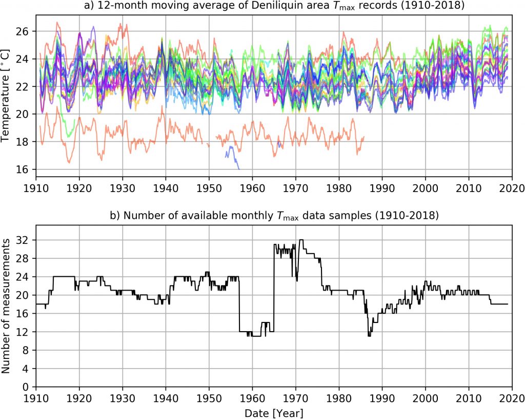
AI research over the last couple of years at the University of Tasmania could have been a check on the existing mess with historical temperature reconstructions. Reconstructions that suggest every next year is hotter than the last the world over. Except that Jaco Vlok began with the Australian Bureau of Meteorology’s temperature datasets without first undertaking adequate quality assurance (QA).

Remember the infamous Climategate emails, and in particular the ‘Harry read me files’? Harry, working at the Climate Research Unit (CRU) at the University of East Anglia, wrote:

Getting seriously fed up with the state of the Australian data. so many new stations have been introduced, so many false references … so many changes that aren’t documented. Every time a cloud forms I’m presented with a bewildering selection of similar-sounding sites, some with references, some with WMO codes, and some with both. And if I look up the station metadata with one of the local references, chances are the WMO code will be wrong (another station will have it) and the latitude/longitude will be wrong too.

For years, the Australian Bureau of Meteorology has been capitalizing on the mess that by its very nature throws up ‘discontinuities’ that can subsequently be ‘homogenized’ … so Blair Trewin is obliged to apply algorithms, to ensure every reconstruction shows steadily rising temperatures in accordance with theory.

As Christopher Booker explained some years ago:

What is tragically evident from the Harry Read Me file is the picture it gives of the CRU scientists hopelessly at sea with the complex computer programmes they had devised to contort their data in the approved direction, more than once expressing their own desperation at how difficult it was to get the desired results.

In short, Phil Jones at the Climatic Research Unit in the UK, Gavin Schmidt at GISS NASA in New York, and even David Jones at the Australian Bureau in Melbourne have overseen the reworking of climate data until it fits the theory of catastrophic anthropogenic climate change (AGW).

They have, in fact, become the masters of Wiener’s Law, without actually knowing the first thing about AI.

They have overseen the use of algorithms – independently of the checks and balances routinely applied in the mainstream AI community – to recreate past temperatures.  In the process the Medieval Warm Period (MWP) and the temperature extremes of the late 1930s, so evident in the raw data for both Australia and also the US, have been removed from our historical temperature records. Thus, we have the Paris Accord, and a federal election in Australia where both candidates for future Prime Minister are committed to saving the environment from rising temperatures even if it means ruining the economy.

The history of science would suggest that disproving a failed paradigm is always more difficult than replacing one, and so I have thought beginning afresh with the latest AI techniques had merit.   But this work is only likely to succeed if the Australian raw temperature database – known as ADAM – is reworked from the beginning.  Otherwise artificial warming from both the Urban Heat Island (UHI) effect and also the Bureau’s new electronic probes in Automatic Weather Stations (AWS), that record hotter for the same weather, will keep creating hockey sticks as inescapably as Groundhog day.

While artificial intelligence, and in particular ANNs, are now considered a mature technology used for a variety of tasks that require pattern recognition and decision making and forecasting – their capacity is denied by mainstream climate scientists.  One of the reasons is that leading climate scientists claim the natural climate cycles have been so perturbed by carbon dioxide that the patterns no longer persist.  This is of course little more than a hypothesis, which can be tested using ANNs as a research tool.

It has been my experience that the raw measurements of any variable associated with weather and climate, when arranged chronologically, show a pattern of recurring cycles.

These oscillations may not be symmetrical, but they will tend to channel between an upper and lower boundary – over and over again. Indeed, they can be decomposed into a few distinct sine waves of varying phase, amplitude and periodicity.  It could be the case that they represent actual physical phenomena, which drive continuous climate change.

If this is the case, it may be possible to forecast the climate including temperature, wind speed and direction and even rainfall, by understanding its component parts.  As long as the relationships embedded in the complex oscillation continue into the future, a skilful weather and climate forecast is theoretically mathematically possible using ANNs – despite chaos theory.

Skilful weather and climate forecasts using ANN represent a new application for an existing technology.  Indeed, if only a fraction of the resources spent applying this technology to mining social media data for advertising, could be diverted to the goal of better climate forecasting I’m sure more major advances would be made very quickly.  But in the case of Australia, the databases will first need to be reworked to install some integrity.

In particular, every time there is a significant equipment change (for example, a change from a mercury thermometer to an electronic probe in an automatic weather station) then that temperature series needs to be given a new ID.  In this way the ANN has some hope of finding the real patterns in climate change from the artificial warming embedded with the new equipment … or the growth of a city.

Innovation, while usually technological, often has a real political implication.  For example, with the invention of the printing press in the 1430s, suddenly there was an efficient way of replicating knowledge – it became harder to control the information available to the masses.

Since the printing press, there have been many other inventions that have dramatically improved our quality of life including the invention of the steam engine in 1712, the telephone in 1876, penicillin in 1928 and personal computing as recently as the 1970s.  Today more people are living longer, healthier and more connected lives thanks to these and other innovations.  But when we consider the history of any single invention we find that it rarely emerged easily: there was initially confusion, followed by resistance.

The history of innovation (and science) would suggest that only when there is opportunity for competition do new and superior technologies take hold.  Of course, this does not bode well for the adoption of AI for weather and climate forecasting by meteorological agencies because they are government-funded monopolies. Furthermore, they are wedded to general circulation modelling that is a completely different technique – based on simulation modelling and next year being hotter than the last.

To be clear, there is the added complication that simulation modelling is integral to demonstrating anthropogenic global warming, while ANN rely exclusively on assumptions about the continued existence of natural climate cycles.  To reiterate, it has been said that because elevated levels of carbon dioxide have perturbed weather systems, ANNs will not work into the future because the climate is on a new trajectory. Conversely, if ANN can produce skilful climate forecasts then arguably anthropogenic climate change is not as big an issue as some claim.  Clearly, as with the printing press, there are political consequences that would follow the widespread adoption of AI in climate science for historical temperature reconstructions and also weather and climate forecasting.  I’m hoping this could begin with more funding for the important work of Jaco Vlok – but perhaps not at the University of Tasmania or with Australian temperature data.

The new report by Jaco Vlok ‘Temperature Reconstruction Methods’ can be downloaded here, and my explanation of its importance and limitations ‘New Methods for Remodelling Historical Temperatures: Admirable Beginnings Using AI’ can be downloaded here.

The feature image (at the very top) shows Jaco Vlok (left) then Jennifer Marohasy, John Abbot and JC Olivier.

**********

Figure 50 from the new report by Jaco Vlok showing monthly mean maximum temperatures from the 71 locations used to recreated the temperature history at Deniliquin.

RP-AI-JVD-Overview-20190517-test

Filed Under: Information Tagged With: temperates

Bramston Reef Corals – The Other Side of the Mud Flat

May 6, 2019 By jennifer

THE First Finding handed down by Judge Salvador Vasta in the Peter Ridd court case concerned Bramston reef off Bowen and a photograph taken in 1994 that Terry Hughes from James Cook University has been claiming proves Acropora corals that were alive in 1890 are now all dead – the fringing reef reduced to mudflat.

Meanwhile, Peter Ridd from the same university, had photographs taken in 2015 showing live Acropora and the need for quality assurance of Hughes’ claims.

Both sides were preparing evidence for over a year – with the lawyers apparently pocketing in excess of one million dollars – yet there was no interest in an independent assessment of the state of Bramston reef.

It more than once crossed my mind, that with all the money floating around for reef research and lawyers … there could perhaps be some mapping, or just one transect, at this most contentious of locations supposedly indicative of the state of the Great Barrier Reef more generally.

In his judgment Judge Salvadore Vasta was left to simply conclude that it was unclear whether there was now mudflat or coral reef where an extensive area of Acropora coral had been photographed back in 1890, but that Peter Ridd nevertheless had the right to ask the question.

Indeed, the court case and the appeal which must be lodged by tomorrow (Tuesday 7th May), is apparently all about ‘academic freedom’ and ‘employment law’, while the average Australian would perhaps be more likely to care if they got to see some coral and some fish – dead or alive.

I visited Bramston Reef over Easter because I couldn’t wait any longer to know if the corals in Peter Ridd’s 2015 photographs had been smashed by Cyclone Debbie that hovered over Bowen two years later, in April 2017.

As I drove into Bowen, I took a detour towards Edgecombe Bay, but I didn’t stop and explore – because I saw the signage warning of crocodiles.

Peter Ridd had told me that his technicians had approached from the south south-east in a rubber dinghy to get their photographs. The day I arrived (April 18, 2019), and the next, there was a strong south south-easterly wind blowing, and no-one prepared to launch a boat to take me out.

On the afternoon of Easter Friday – ignoring the signage warning of crocodiles – I walked through the mangroves to the water’s edge. I found the mudflat which Terry Hughes had claimed now covers once healthy Acropora coral and walked across it. The other side of the mudflat there was reef flat with beds of healthy Halimeda. This area of reef flat over sand extended for nearly one kilometre – before it gave way to hectares of Acropora coral.

Professor Hughes had just not walked far enough.

When, with much excitement, I showed my photographs of all the Acropora to a Bowen local. He described them as, “rubbish corals”. He seemed ashamed that the corals I had photographed at Bramston reef were not colourful.

For a coral to make the front cover of National Geographic it does need to be exceptionally colourful. Indeed, for a woman model to make the cover of Vogue magazine she needs to be exceptionally thin. But neither thin, nor colourful, is necessarily healthy. Indeed, Acropora corals are generally tan or brown in colour when they have masses of zooxanthellae and are thus growing quickly – and are healthy.

White corals have no zooxanthellae and are often dead, because they have been exposed to temperatures that are too high. Colourful corals, like thin women, are more nutrient starved and often exist in environments of intense illumination – existing near the limits of what might be considered healthy.

Such basic facts are not well understood. Instead there is an obsession with saving the Great Barrier Reef from imminent catastrophe while we are either shown pictures of bleached white dead coral, or spectacularly colourful corals from outer reefs in nutrient-starved waters … while thousands of square kilometres of healthy brown coral is ignored.

Peter Ridd did win his high-profile court case for the right to suggest there is a need for some quality assurance of the research – but I can’t see anyone getting on with this. The Science Show on our National Broadcaster, hosted by a most acclaimed scientist journalist, has reported on the case just this last weekend. Rather than launching a dinghy and having a look at Bramston Reef, Robyn Williams has replayed part of a 2008 interview with Peter Ridd, and let it be concluded that because Peter Ridd holds a minority view he is likely wrong.

Understanding the real state of the Great Barrier Reef is not a trivial question: it has implications for tourism, and the allocation of billions of dollars of public monies … with most currently allocated to those properly networked – but not necessarily knowledgeable or prepared to walk beyond a mudflat to find the corals.

Signage warning of crocodiles.
Photographs of the Acropora out of the water where taken about here.
There is a mudflat to the west of Bramston Reef.
That mudflat is teeming with life, as expected in an intertidal zone.
This Porites coral is a healthy tan colour.
After the mud flat there was reef flat, with coarse sand and lots of Halimeda. All healthy, and typical of an inner Great Barrier Reef.
Halimeda is a green macroalgae, it was healthy.
Acropora corals with a view to Gloucester Island.
I did find one bleached coral.
Most of the Acropora was a healthy brown colour suggesting good growth, rather than beauty.
There were also corals to the south east.
Looking across to Gloucester Island, in front of the mangroves when the tide was in, early on 19 April.
Looking towards Gloucester Island, the day before.

To be sure to know when I post pictures at this blog, and to get the latest news regarding the Peter Ridd court case including the possible appeal by James Cook University, subscribe for my irregular email updates.

Filed Under: Information Tagged With: Great Barrier Reef

Bring Back the Tide: Wash-Away Adelaide Politics

May 1, 2019 By jennifer

RECENT billion-dollar plans for the Murray Darling Basin have never been about the environment. Rather they have been about special interest groups doing deals through constant negotiation, with commercial interests in South Australia generally trumping all others.

As Geoff Adams recently explained – with his newspaper article republished in various regional newspapers – Waterfront houses on Hindmarsh Island and its marinas sell for between $500,000 and more than $1 million. Some of this real estate has been planned around the marina where jetties are built to a fixed sea level height, never mind that without the barrages the lake is a naturally tidal estuary, that could be swamped by global warming.

I could go on … but suffice to say there is nothing sustainable about any of the planning for so many years for the precious fresh water from upstream.

Any rational solution must begin with the dismantling of the 7.6 kilometres of barrages built in the 1930s in an attempt to convert the Murray River’s estuary into a play lake for Adelaide’s elite … to go yachting and water skiing. I’ve written about this many times, including in a 2012 report, which can be summarized:

The Australian Government’s $10 billion tax-payer funded plan to save the Murray-Darling by channeling water from upstream water storages and flood plains to the Lower Lakes, Murray’s mouth and Coorong, is based on a false premise; a misunderstanding of the fundamental nature of the Murray River’s estuary and the coastal processes that continue to shape it.

The Murray River’s estuary was formed 7,000 years ago during a period of rapid sea level rise. It was in an intermediate stage of evolution with the central lagoon developing from intermittently closed to fully tidal, when in the 1930s, sea dykes/barrages were built between the island, just to the north of the sand peninsula and the narrow entrance to the Southern Ocean.

These sea dykes dammed the estuary, stopping the tides, and made the lagoon/Lake Alexandrina totally dependent on Murray River flows. After the Mundoo channel was blocked through the construction of that barrage, sand that shoaled around the Murray’s mouth consolidated creating a new island, Bird Island.

Long-standing government policy and vested interests preclude discussion of the coastal processes that are growing Bird Island that may one day permanently block the Murray’s mouth… inevitably flooding the marina at Hindmarsh Island, and its associated expensive real estate.

Back in 1856, South Australia’s Surveyor General George Woodroffe Goyder recognised the potential of the Mundoo channel to scour the Murray’s mouth. He suggested the natural process of deepening and widening of the Murray’s sea mouth be enhanced by cutting though the rock bar across this channel thus further concentrating tidal water inflow and river water outflow. Instead, over the last 156 years government policy has worked to stop the tide and block the channel – but it’s not too late to change direction and restore the estuary and bring back the tide.

Filed Under: Information Tagged With: Murray River

Smashed by Debbie – Middle Island Corals

April 24, 2019 By jennifer

WE have been led to believe that smashed coral is our fault – that when it is lying on the sea floor as untidy piles of grey it is because of catastrophic human-caused global warming. But just maybe coral bleaching and cyclones are natural, and not even increasing in extent.

I visited four reefs during my recent adventures off Bowen. One of these, the reef fringing Middle Island, has been very badly damaged by cyclone Debbie, which hovered over Bowen in April 2017.

Jen getting ready to take more photographs, off Middle Island, 22 April 2019.

Just two years later much of this reef is unattractive – but certainly not desolate.

After gearing-up I jumped over-board from The Skipper’s boat with my little red Olympus (TG-5) camera on Monday – and my new snorkelling buddy Matt.

Every time I stopped swimming, watched, and waited I saw something special swim past.

This green turtle swam past me, over all the broken grey corals at Middle Island reef, 22 April 2019.

There were also large, colourful parrot fish. But I didn’t manage to capture them on this short video – my first attempt at underwater movie-making.

As I snorkeled sometimes the backdrop was broken coral. Other times I swam over meadows of algae. But I never had to swim far before seeing something special – like a mushroom or staghorn coral. They were often solitary: the very early stages of regeneration at an otherwise often ugly reef.

This mushroom coral (Fungia sp, family Cnidaria) was in a meadow of algae – alone at the Middle Island reef, on 22 April 2019.
A lonely Acropora, evidence of regeneration off Middle Island, 22 April 2019.

Occasionally I would stumble on an area of faster growing soft coral with sponges.

In some places soft corals and sponges are already growing back, off Middle Island on 22 April 2019.

That the cyclone had smashed large Porites coral clear in half gives some idea of how powerful it was.

A Porites coral smashed in half, most likely from the force of the waves pounding from the cyclonic winds two years ago off Middle Island when Cyclone Debbie struck.

But even delicate black feather corals are coming back … one at a time.

Black feather coral, growing alone on a hollowed out Porites – under the water off Middle Island, 22 April 2019.

********

The first/feature photo is of me (Jennifer Marohasy) getting ready to jump in, with a view across to the north eastern edge of Middle Island, off Bowen, on 22 April 2019; photo credit John Barnes.

The first link embedded into this post is from the Bureau’s website suggesting a declining, certainly not increasing, trend in the incidence of cyclone. I’ve just downloaded this page and am archiving it here: TropicalCycloneTrends-20190424

Also, it should be noted, that the Bureau did overhype the category for Cyclone Marcia, as I detailed in an article for On Line Opinion, also archived here: CycloneMaricawasnotcategory5-Queenslanders . The Bureau were much more accurate when it came to reporting of Cyclone Debbie.

Filed Under: Information Tagged With: Great Barrier Reef

The Eerie Ancient Coral Reef at Bowen, with a Crocodile

April 22, 2019 By jennifer

MOST people rarely venture into nature – they certainly don’t spend much time on coral reefs. When they do, they may expect the fish and corals to be as bright, colourful and perfect as the last nature documentary that they saw in full surround-sound on a wide screen.

Such images come from professional photographers staying underwater for hours, perhaps after having waited days for very calm weather, so the water is exceptionally clear. Of course, such photographs are enhanced by bright lighting, so most of the footage would be taken on very sunny days. Also, a great expanse of shallow water – gives depth to the footage, and the further off-shore generally the clearer the water.

Hard coral at Horseshoe Bay growing next to an oyster bed – my first underwater photograph (20 April 2019). I saw the same type of coral, but in shades of green, pink and purple at Bramston Reef at depth on 21 April 2019.

The Great Barrier Reef is vast. If you click onto the webpage at this link you will find zoning maps that give an idea of how long and how wide – in fact the area is visible from outer space.

Scroll down and click on Map 9, and you will find a map showing so many reefs off Bowen.

Bowen has made headlines for some years now – it is the place where Terry Hughes and other leading academics claim the reef is totally dead, and that this is representative of the whole inshore Great Barrier Reef. They are so wrong.

There is so much coral here off Bowen, and there are so many extensive areas of coral reef, and most are a very long way off shore – making the visit to just one of the outer reefs a long day trip by fishing boat.

Because cyclones and coral bleaching are a regular occurrence, the exact state of the corals at particular reef is not always predictable and in constant flux. This has been the case for thousands of years.

The Great Barrier Reef has existed for about 10,000 years: when sea levels rose at the beginning of the current geological epoch known as the Holocene. Because the reefs have been growing up-wards for thousands of years – while sea levels have fallen over one metre in the last 5,000 years – they are very vulnerable to bleaching, particularly when there is calm weather on a very low tide leaving corals high and dry for long periods.

Nevertheless, it is possible to find so much healthy coral, even at Bowen … at Horseshoe Bay, which is just around the corner from Queens Bay that is shown in the far-left corner of Map 9.

I’ve been in Bowen for several days now … waiting for the strong south-southeasterly winds to ease so we can take the boat out to visit some off-shore islands. The Skipper did take me out late yesterday (when we had a few hours of calm) to see the coral the other side of Bramston reef – I’m meaning beyond the mud flat and reef flat that I walked last Friday on the very low tide.

It is so wrong for Terry Hughes to suggest that this reef has all been reduced to mud flat. That the coral off Bowen is all dead.

There is live coral, and lots of it, at depth at Bramston reef. I got lots of photographs from my cheap camera and just snorkelling (no tank) and I might post more in due course.

A great diversity of soft corals just off Bowen, 21 April 2019.

My preference would be to get a professional underwater photographer to take better photographs and as a movie so you can see the full extent of this ancient reef.

Late yesterday some of Bramston reef looked so eerie – then again it is about 4,500 years old.

Someone needs to go down with a good camera and a tank of oxygen and get extensive footage that shows the great diversity, and all the fish – there might even be a crocodile hiding somewhere.

Parts of Bramston reef have been reduced to rubble, some from Cyclone Debbie that hovered over Bowen just two years ago. But there is also new coral, and extensive areas of healthy and live corals at this ancient reef.

No filter, no colour touch-up … Matt snapped this image at Bramston reef some metres down, yesterday.

I’m hoping to see another ancient reef off Bowen this afternoon … perhaps the Skipper and Matt will take me to Middle Island.

In the meantime, subscribe at my blog, so you are sure to be one of the first to find out when, and if, I can find a professional underwater photographer to show you ancient Bramston reef, including the crocodile.

If you are impatient and overseas, just jump on a plane and then bus or train it to Bowen. Nicole Kidman has even been here, but she thought Bowen was Darwin. Don’t believe Hollywood, the academics or doomsayers (the Elites can be so lame) – there is so much more than mudflats and cowboys at Bowen.

Matt snorkeling with me off Bowen, yesterday. The water looks very blue, but visibility was poor once you put your bottom-up and swam down very far. It is not always like this, sometimes the water is so crystal clear, especially here, off Bowen.

*****
The feature image is of me, and very happy, because I had just been snorkeling at Horseshoe Bay (Bowen) – and there are so many pretty corals, and I saw a sting ray.

Photo credit John Barnes.

Filed Under: Information Tagged With: Great Barrier Reef

Denying the Littoral Zone at the Great Barrier Reef

April 20, 2019 By jennifer

The coral reef off Bowen, in North Queensland, is only dead to the 2,500 marine scientists who attended the conference in Cairns on 9th July 2012. That day, they were shown photographs of a mudflat … and told that mud now covers what was once healthy coral reef, and that this reef off Bowen is an example of the “sad decline” of the Great Barrier Reef.

The photographs shown by Terry Hughes on that day were misleading.

There is still a lot of coral off Bowen. At Bramston Reef it is more than one kilometre off shore, beyond the mudflat, and beyond the reef flat – both of which are teeming with life.

This is the littoral zone: the area between the highest and lowest tides once of so much interest to biologists. But like so much of our natural history it is being denied by the doomsayers and activists who now manage the narrative and seem completely averse to a bit of mud. They seem to expect the entire shoreline to be covered in bright corals with Nemo swimming around, but this was never the case.

Yesterday, on the very lowest tide of this month, I walked across an expanse of mudflat and then sandy reef flat before finding myself blocked by Acropora coral, which would normally be underwater. I could see massive Porites just out of the water in the distance. But the tide was turning, and so I headed back.

Corals, normally underwater, exposed at the very lowest tide on 19 April 2019, 1.3 km from the high water mark on the mainland – not far from Stone Island.

I took photographs along the way of the many creatures that inhabit this littoral zone – that is not all covered in mud, but some of it is and that is not bad.

For years, photographs of just the mud flat with a view across to Gloucester Island (with Stone Island to the left in the foreground, of the next video), have been paraded as evidence of “devastated coral reefs” – including by Terry Hughes at that conference.

The photographs are just of the naturally muddy, what some would call “back reef”. Beyond that is an area of perhaps 900 metres dominated by coarse carbonate sands, and beyond that corals for perhaps 800 metres to the seafloor. Yesterday I walked across the mud flat and reef flat to the corals.

The most high-profile Great Barrier Reef researchers have denied the existence of the reef flat and then the corals at Bramston reef, which they variously confuse with the fringing reef at Stone Island. It is a shame. It suggests a high level of incompetence.

Bramston reef was probably at its most expansive and spectacular about 4,500 years ago when sea levels were about 1.5 metres higher (yes, higher). That was during the Holocene high stand.

Back then there would have been rapid vertical growth of the reef. By 3,000 years before the present, the reef was probably backfilling with the sea-level fall creating fossil microatolls.

That there is limited potential for vertical growth at present, has everything to do with the lack of sea level rise. Sea levels did come up over 100 meters between about 16,000 and 10,000 years ago! The climate is always changing. Indeed climate change began long before the industrial revolution.

It is confusing to me that while sea level fall is an un-controversial fact in the technical literature, there is so much concern about the perhaps 36 cm rise since about 1880 along the Queensland coast. Indeed, what is written in the newspapers is impossible to reconcile with what is in the technical, scientific literature. This is often the case with climate issues.

At Bramston reef the difference between high and low tide at this time of year is more than three metres. There will be much more coral exposed in August, when we get the very lowest tides for this part of the Earth for this year – and I’m planning to return then, to get more photographs, including of the corals.

Delicate Halimeda, amongst the mud.

********
The feature image (very first photograph, at top) is of a young Porites coral growing around mud on the reef flat taken by Jennifer Marohasy on 19th April 2019.

I’m still learning how to take a good ‘selfie’ … walking out to the reef, 19 April 2019.

Filed Under: Information Tagged With: Great Barrier Reef

  • « Go to Previous Page
  • Go to page 1
  • Interim pages omitted …
  • Go to page 14
  • Go to page 15
  • Go to page 16
  • Go to page 17
  • Go to page 18
  • Interim pages omitted …
  • Go to page 607
  • Go to Next Page »

Primary Sidebar

Recent Comments

  • Ian Thomson on Vax-ed as Sick as Unvax-ed, Amongst My Friends
  • Dave Ross on Vax-ed as Sick as Unvax-ed, Amongst My Friends
  • Dave Ross on Vax-ed as Sick as Unvax-ed, Amongst My Friends
  • Alex on Incarceration Nation: Frightened of Ivermectin, and Dihydrogen monoxide
  • Wilhelm Grimm III on Incarceration Nation: Frightened of Ivermectin, and Dihydrogen monoxide

Subscribe For News Updates

  • This field is for validation purposes and should be left unchanged.

December 2025
M T W T F S S
1234567
891011121314
15161718192021
22232425262728
293031  
« Jan    

Archives

Footer

About Me

Jennifer Marohasy Jennifer Marohasy BSc PhD has worked in industry and government. She is currently researching a novel technique for long-range weather forecasting funded by the B. Macfie Family Foundation. Read more

Subscribe For News Updates

Subscribe Me

Contact Me

To get in touch with Jennifer call 0418873222 or international call +61418873222.

Email: jennifermarohasy at gmail.com

Connect With Me

  • Facebook
  • LinkedIn
  • RSS
  • Twitter
  • YouTube

Copyright © 2014 - 2018 Jennifer Marohasy. All rights reserved. | Legal

Website by 46digital